High Seat & Bleaberry Fell from Keswick
Lake District Walk
Nat Park - Lake District - Lake District Central Fells
Wainwrights - Bleaberry Fell, High Seat
County/Area - Cumbria
Author - Lou Johnson
Length - 9.0 miles / 14.6 km Ascent - 1960 feet / 594 metres
Time - 6 hours 30 minutes Grade - moderate
Maps 

| Ordnance Survey Explorer OL4 | Sheet Map | 1:25k | BUY |
| Anquet OS Explorer OL4 | Digital Map | 1:25k | BUY |
| Ordnance Survey Landranger 90 | Sheet Map | 1:50k | BUY |
| Anquet OS Landranger 90 | Digital Map | 1:50k | BUY |
Walk Route Description
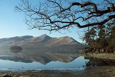
Click image to visit gallery of 12 images.
The territory covered by this Lake District walk is full of contrasts from the shores of Derwentwater with views to Catbells and the north-western Fells to open fells where Lakeland panoramas rule supreme. The open fellside between the two summits is often wet under foot and it is best to complete this walk either after a dry spell or during days when the peat is frozen hard.
The car park adjacent to the Theatre and main landing stage in Keswick (grid ref. NY265228) is the best place to start. From here follow the road downhill towards the lakeside and follow the clear path heading south. The lakeside section is full of fine viewpoints and the first of these is Friars Crag from where you get a fine view south to Borrowdale. Stay with the main path, which briefly leaves the shore at the Ings to regain it shortly afterwards at Stable Hills.
Calfclose Bay is soon reached and here you have to climb up to the roadside footpath. On reaching the junction to Watendlath turn left and follow the lane steeply uphill to reach Ashness Bridge. Just before the bridge take the path left. This contours across the hillside to pass through a wall. Just after turn right and follow the path uphill. You will scramble up a few low rock steps and leaving the well trodden route take to the open fellside and head northeast aiming for the sheepfold marked on the OS map (grid ref. 278201). Despite the lack of path the going is fairly straightforward and providing you go uphill you cannot really go wrong!
Reaching the sheepfold you will meet the main path from Walla Crag to the summit of Bleaberry Fell. Turn right along this well marked route and head for the summit cairn. Nearing the top the path steepens but quite soon you will be enjoying the views to Helvellyn and Blencathra. You can see the next objective, High Seat, about a mile south. This is the section of path that can be very wet and boggy. In general the route is easy to follow and provided you stay on the west side of the fence you will reach a cross fence with a stile. Go over this and the summit will be gained after a mild scramble to enjoy even better views in every direction.
From High Seat retrace your steps to Bleaberry Fell perhaps taking the path on the western slopes that avoids a second visit to the summit. Continue downhill past the sheepfold with the next objective of Walla Crag now in view. The best viewpoint is reached by crossing a stile to reach an open area with a grandstand view of Derwentwater and Skiddaw. After taking in the view recross the stile to rejoin the main path and follow it north-westwards with a wall on your left. The path starts to descend quite steeply reaching a lane at Rakefoot.
Follow the lane for a short way and take the first signed footpath on your left. This leads down over a footbridge before descending further through Springs Wood to reach a residential road (grid ref. 272226). With the housing on your right head in the direction of Keswick. After approximately 400 metres turn left down a signed footpath. This leads through Castlehead Wood to reach the main Borrowdale Road. (If you have the energy you can make the short diversion to the summit of Castlehead from where there is an excellent view across Derwentwater). Reaching the road turn right and continue on the roadside footpath to the first roundabout. Here you should take the left turn to reach a second roundabout. Turn left again and the car park where you started is on your left.
Other walks nearby
| Walk 2587 | Castlerigg Stone Circle & St John's in the Vale | easy/mod | 8.5 miles |
| Walk 1356 | Walla Crag | easy/mod | 4.5 miles |
| Walk 2036 | Cat Bells from Gutherscale | easy/mod | 4.0 miles |
| Walk 3525 | Cat Bells (Route 2) | easy/mod | 4.0 miles |
| Walk 3119 | The Newlands Horseshoe - Catbells, Dale Head & Hindscarth | mod/hard | 12.0 miles |
| Walk 1073 | Skiddaw & Glenderaterra Beck | moderate | 9.0 miles |
| Walk 1244 | Lonscale Fell & Latrigg | moderate | 7.5 miles |
| Walk 1108 | Ashness Bridge & Grange Fell | moderate | 9.0 miles |
| Walk 1155 | Causey Pike | moderate | 6.3 miles |
| Walk 1120 | Grisedale Pike & Crag Hill fro Braithwaite | mod/hard | 8.5 miles |
Recommended Books & eBooks
Lake District: High Level and Fell Walks
 This guidebook describes 30 graded fell walks on the ridges and high peaks of the English Lake District, the UK's most popular national park. Reaching some of England's finest and highest mountain scenery, this guide leads readers to classic horseshoes and traditional ascents as well as lesser-known routes to quieter summits.
More information
Walking the Lake District Fells - Mardale and the Far East
 Part of the Walking the Lake District Fells series, this guidebook covers a wide range of routes to 36 Lakeland summits that can be climbed from the Ullswater, Haweswater, Troutbeck, Kentmere and Longsleddale valleys, with highlights including High Street, Place Fell and the Kentmere fells. Suggestions for longer ridge routes are also included.
More information
Messaging & Social Media
Message Walking Britain and follow the latest news.

Mountain Weather
Stay safe on the mountains with detailed weather forecasts - for iOS devices or for Android devices.