Walk 1009 - printer friendly version
The Wrekin Walk
Author - Lou Johnson
Length - 3.0 miles / 4.9 km
Ascent - 820 feet / 248 metres
Grade - easy/mod
Start - OS grid reference SJ638092
Lat 52.679281 + Long -2.5368732
Postcode TF6 5AL (approx. location only)
Of volcanic origins the Wrekin is one of a string of hills stretching from Telford south to Church Stretton near the Long Mynd. The Wrekin has close associations with the surrounding area and dominates the landscape around the modern town of Telford. This direct approach is a straightforward half day walk and offers a grandstand view of the surrounding countryside over a wide area. On a clear day the view extends as far north as Jodrell Bank with the Welsh mountains filling the skyline to the west. In good weather the route can be busy and parking can be very limited.
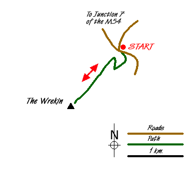
The start is the car park (Grid ref. SJ638092) on the minor road leading from Junction 7 of the M54 to the village of Little Wenlock. After parking cross the road and take the footpath that bears left in front of the derelict toilet block. Climbing gently the path turns south-west to reach a junction (Grid ref. SJ637088). Turn right here and continue climbing past the cafe and through a gate. The wide path (or track) turns through 180 degrees and continues climbing along the main ridge. Passing a radio tower, the topograph and trig point come into view. It is from these that the best views can be had. To return to the start simply retrace your steps.
Messaging & Social Media
Message Walking Britain and follow the latest news.

Mountain Weather
Stay safe on the mountains with detailed weather forecasts - for iOS devices or for Android devices.