Walk 1017 - printer friendly version
Stac Pollaidh Walk
Author - Lou Johnson
Length - 3.0 miles / 4.9 km
Ascent - 1750 feet / 530 metres
Grade - easy/mod
Start - OS grid reference NC107095
Lat 58.03414 + Long -5.2079218
Postcode IV26 2YB (approx. location only)
Stac Pollaidh is a small hill by Scottish standards yet it attracts many people than one might imagine. Occupying a solitary position in Assynt in northwest Scotland and with an unmistakable profile it soon becomes evident why this hill is climbed by so many people.
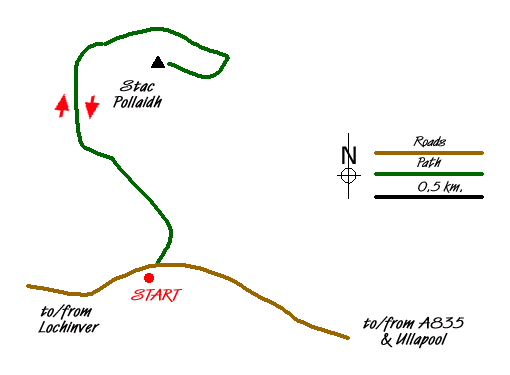
There is small car park (grid ref. NC107095) on the minor road running from the A835 Ullapool to Kylesku road to Lochinver. Cross the road and take the obvious path. You go through a deer fence and continue steeply uphill. Just after the second gate the path divides. Turn left here and still climbing, traverse the wild moorland across the southern face of the hill. The path is well constructed and eventually turns north and then east to reach the northern aspect of Stac Pollaidh.
Continue on the path to join the path coming from the other way and climb again more steeply onto the main ridge of the hill. The views are stupendous with many of the iconic hills of Sutherland including Cul Mor, Suilven, Canisp, and Quinag. If the weather is clear then the panorama will include many more hills in this beautifully wild part of Scotland.
For most people making the ascent onto Stac Pollaidh few will make the true summit. This requires a head for heights and some scrambling skills. Do be careful and do not over estimate your abilities. Despite its modest height this is a serious summit and the most challenging in the area. Despite not making the top you can still enjoy the views which are little different than from the true summit.
My preferred descent is to reverse the outward route and not make the full circular trip. Why? I suppose it is much quieter on the western half of the circuit than what most perceive as the shortest and more direct route at the eastern end of the hill. The descent is very pleasant with beautiful views ahead all the way down to the car park.
Messaging & Social Media
Message Walking Britain and follow the latest news.

Mountain Weather
Stay safe on the mountains with detailed weather forecasts - for iOS devices or for Android devices.