Walk 1039 - printer friendly version
Am Bodach and Stob Coire a' Chairn Walk
Author - Peter Smyly
Length - 9.5 miles / 15.4 km
Ascent - 4100 feet / 1242 metres
Grade - mod/hard
Start - OS grid reference NN187618
Lat 56.712579 + Long -4.9637228
Postcode PH50 4RR (approx. location only)
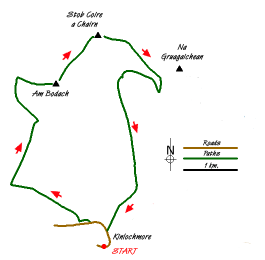
Although this circular walk in the Mamores range includes two of the Munros that form part of the Ring of Steall, walkers wishing to do the horseshoe in either direction are better advised to start from Glen Nevis to the north. Kinlochleven's position to the south does not lend itself to such a traverse unless one is not averse to a certain amount of backtracking up and down high, rugged and rocky mountains that rank among Scotland's finest with some eye-catching scenery of high mountains including. Ben Nevis.
From Kinlochleven, the initial route follows part of the West Highland Way in a north-westerly direction for about a mile. As the path gains altitude, there is a fine view looking back down on Kinlochleven. You need to take a track that branches off to the right. This path leads into a wild valley, Coire na h-Eirghe, between Stob Coire na h- Eirghe and Sgurr an Fhuarain, as it gains height steadily with Am Bodach above on the right. The path leads to a bealach and reveals several of the Mamores peaks. This is a good point to pause for a break before tackling the steep pull up to Am Bodach. The summit area of Am Bodach may not be the most memorable, but the narrow steep ridge leading to its top and the descent that follows is likely to be more so. Mountains can create different impressions in the minds of walkers and in the case of Am Bodach, the final ascent from the bealach between it and Sgurr an Lubhair is, in the latter stages so steep that the mountain seems much higher than it actually is. I would offer one word of warning regarding this walk, however, and that is, that the descent from Am Bodach down to the next dip is one where particular care needs to be taken, even in good weather conditions, for not only is it steep but there are loose stones and rocks aplenty and just one lapse of concentration or misplaced footstep could dislodge one of them.
By way of contrast, the walk up to Stob Coire a Chairn is relatively easy and straightforward up a grassy slope with a more or less level summit area marked by a small pile of stones. Attention is drawn to the next peak in the horseshoe to the north-east, An Garbhanach which offers a tempting, though steep and rocky prospect for the next summit if it is decided the route should follow this direction. Binnein Mor and Na Gruagaichean also loom large to the east across the valley. If descending to Kinlochleven, a path now heads more or less due east, then south-east and skirts the lower slopes of Na Gruagaichean before doubling-back to reach the upper regions of Coire na Ba with Am Bodach now towering above across the valley ahead. The path leads down to the Mamore Lodge (Hotel) and back down to Kinlochleven and the start point of the walk.
Messaging & Social Media
Message Walking Britain and follow the latest news.

Mountain Weather
Stay safe on the mountains with detailed weather forecasts - for iOS devices or for Android devices.