Walk 1241 - printer friendly version
Arthur's Pike & Loadpot Hill Walk
Author - Lou Johnson
Length - 9.0 miles / 14.6 km
Ascent - 2080 feet / 630 metres
Grade - moderate
Start - OS grid reference NY435191
Lat 54.563958 + Long -2.8752953
Postcode CA10 2NF (approx. location only)
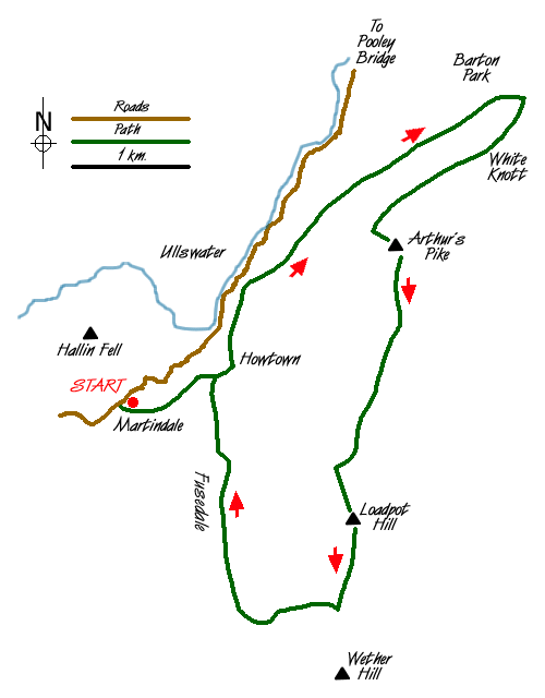
A Lake District circular walk of contrasts exploring the northernmost section of the High Street range. The first section is pleasant low level walking with limited views across Ullswater and to the crags of Bonscale Pike. The route changes in character as you follow the High Street ridge before dropping down for a pleasant walk through Fusedale.
The walk starts at the new Martindale Church (Grid ref. NY435191) where limited parking is available and it is worth remembering that on busy days you may have to seek out another spot to park. From the parking area head south keeping the church on your left crossing an area of rough pasture to locate a clear track that descends northeast into Howtown. Stay on this track passing Mellguards where the route swings north.
There now follows a lengthy section keeping the intake wall on your left to reach Auterstone Wood. En-route you will have passed the dramatic ravine that contains Swarthbeck Gill, which drains much of the high ground used for the middle section of the walk. After Auterstone Wood the path leaves the intake wall and heads across open fellside climbing steadily to reach a junction of paths (Grid ref. 473220). Turn sharp right here and continue climbing southwestwards to reach a rocky knoll marked as White Knotts on the OS 1:25000 map. This makes an ideal place to stop and take in the view.
Leaving White Knotts take the narrow path that follows the 'edge' heading southwest along the top of the crags. To your right there are superb views across Ullswater to the high fells of the Helvellyn range. After about a mile you will reach a large cairn. This offers a grand panorama over almost the whole of Ullswater. From this cairn follow a feint path southeast to gain the cairn on the summit of Arthur's Pike. Care is needed to ensure you now locate the right path and looking south you will see a path junction (Grid ref. 461204). Take the broader path heading south. This will lead you onto the old Roman Road.
Follow this in the same direction towards the round shape of Loadpot Hill. The main path contours around the western flank and you should leave this continuing straight on to reach the summit of Loadpot Hill. The view is not spectacular but it does mean you have conquered another 'Wainwright'. Head off the summit in a southerly direction to rejoin the main path close to the ruins of the chimney marked on maps.
On your right (Grid ref. 455173) you will notice a feint path heading west down the northern side of Groove Gill. This path is not marked on maps. A short way after leaving the Roman Road the path fades to nothing and you need to descend over grass keeping the gill on your left. After a few minutes of descent you will notice a path crossing the Gill and you should use this to gain the southern bank. Continue your descent and you will soon join a grassy path for the remainder of the descent into Fusedale.
Continue on the main valley path, passing a derelict barn, to reach the track you used for the first section of the walk. Turn left and after a gentle ascent you will arrive back at the start.
Messaging & Social Media
Message Walking Britain and follow the latest news.

Mountain Weather
Stay safe on the mountains with detailed weather forecasts - for iOS devices or for Android devices.