Walk 1253 - printer friendly version
Booze & Slei Gill from Langthwaite Walk
Author - Lou Johnson
Length - 2.5 miles / 4.1 km
Ascent - 400 feet / 121 metres
Grade - easy
Start - OS grid reference NZ005023
Lat 54.416145 + Long -1.9938027
Postcode DL11 6RF (approx. location only)
Although short, this Yorkshire dales walk includes all the characteristics of the northern part of this beautiful National Park. Beginning in a compact stone built village, it continues through pastures with dry stone walling to explore the remnants of the once extensive lead mining industry. The walk concludes with a pleasant section through deciduous woodland alongside Arkle Beck, one of the tributaries of the River Swale.
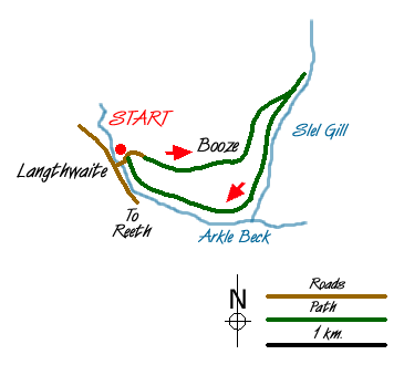
The start is the small car park in the centre of Langthwaite village (Grid ref. NZ005023). Should this be full do ensure that you park considerately and avoid causing any obstructions. After parking head northeast between stone cottages on the lane to Booze. This climbs steeply for a short way soon providing a bird's eye view over the village and Arkengarthdale.
Continue through the hamlet of Booze. The lane becomes a track, which contours the hillside eventually crossing the grassed-over remains of the lead mining to reach a barn. The track descends to Slei Gill. You can if you wish walk upstream and explore some more although this route turns back here and follows the Gill downstream. On the hillsides you can see the old 'hushes' where lead was found by scouring the hillside with water that had been temporarily dammed. Continue to follow Slei Gill, ignoring paths left and right. The path enters mature deciduous woodland before continuing alongside Arkle Beck and meadows back to the village.
Messaging & Social Media
Message Walking Britain and follow the latest news.

Mountain Weather
Stay safe on the mountains with detailed weather forecasts - for iOS devices or for Android devices.