Walk 1282 - printer friendly version
Malham Tarn & Arncliffe Walk
Author - Lou Johnson
Length - 12.5 miles / 20.3 km
Ascent - 1650 feet / 500 metres
Grade - moderate
Start - OS grid reference SD904656
Lat 54.086221 + Long -2.1482465
Postcode BD24 9PU (approx. location only)
This lengthy Yorkshire Dales walk provides an insight into the limestone uplands to the north of Malham, visits the picturesque village of Arncliffe and provides plenty of exercise. Despite the length nowhere is it hard going and with an interesting pub in Arncliffe you can take a break. There is very little shelter en-route so try to avoid heavy rain or high winds.
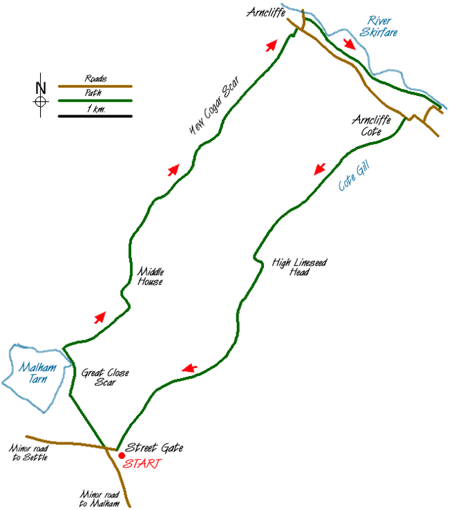
The start is 'Street Gate' (Grid ref. SD904656) where there is adequate parking on the grass. Head west back along the road and take the first track on your right. This leads you to the shores of Malham Tarn. After following the shore for a short way take the signed path on your right (Grid ref. 897671) that leads you over a grassy col and down towards Middle House Farm. This is the Monk's Path that will be followed all the way to Arncliffe. The path descends towards the farm with a finger post and stile in the fence by the farm access road. Do not cross the stile but follow the track/bridleway north to Middle House, a uninhabited farm that was restored by the National Trust.
Just beyond Middle House ignore the path to Darnbrook instead following a generally clear path through pleasant limestone outcrops to reach the top of Yew Cogar Scar with Cowside Beck far below. Beyond are the slopes of Darnbrook Fell and Fountains Fell. The path stays high above the valley for some way before dropping steeply down into Littondale and the village of Arncliffe leading you quite conveniently past the front door of the Falcon public house. This interesting pub opens from noon to 3 p.m. and serves a limited range of food.
Continue through the centre of the village and turn left down the road to Litton. Just before the church take the footpath on your right. This leads across meadows beside the River Skirfare. Stay on this path until you reach a modern footbridge across the river (Grid ref. 952706). Do not cross the footbridge but exit right onto a narrow tarmac lane and head back towards Arncliffe! Reaching a busier road, turn right still heading back towards Arncliffe. Follow this for a short way before turning left up the access road to Arncliffe Cote.
Stay on the track through a zigzag to climb easily up the valley with Cote Gill on your left. You will makes excellent progress on the grassy track soon reaching the point where Cote Gill drops through a series of waterfalls (Grid ref. 934694). Continuing gently uphill you soon reach High Lineseed Head (Grid ref. 925682) from where the track leads downhill, apart from a final short easy climb, towards Street Gate and the end of the route.
Messaging & Social Media
Message Walking Britain and follow the latest news.

Mountain Weather
Stay safe on the mountains with detailed weather forecasts - for iOS devices or for Android devices.