Walk 1352 - printer friendly version
Tarmachan Ridge Walk
Author - Lou Johnson
Length - 9.4 miles / 15.3 km
Ascent - 2700 feet / 818 metres
Grade - mod/hard
Start - OS grid reference NN608378
Lat 56.511593 + Long -4.2636573
Postcode FK21 8TY (approx. location only)
Meall nan Tarmachan and its associated summits form a superb ridge that provide an impressive backdrop to the village of Killin. Nowhere is the route difficult, although you must ensure that you are properly equipped for what is a true mountain route. In low cloud excellent navigation skills are required as the terrain between the four main summits is confusing in poor visibility and there are a few dangerous crags.
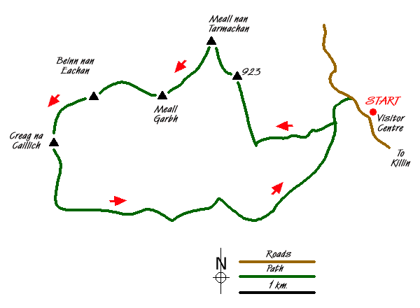
Exit the car park at the Ben Lawers Visitor Centre (Grid ref. NN608378) and walk north along the road. After 400 metres turn left down a track. Limited parking is also available on the track (Grid ref NN603382) between the road and the gate. Go through the gate and walk along the quarry track. Shortly afterwards take the footpath on your right. This climbs easily across the flank of Meall nan Tarmachan's south ridge.
Reaching the ridge, the path turn north and begins to gain height more quickly. As height is gained the views towards Loch Tay and east to Ben Lawers improve and you soon arrive at the 923 m. subsidiary summit (Munro top). Ahead the path dips to a col before climbing the southern face of Meall nan Tarmachan. The path is steep but the ascent is easy and quickly accomplished. The view from the summit cairn is superb and you realise that relatively little effort has been used to reach the Munro. The views in all directions are now superb and you need to allow plenty of time to enjoy these to their full.
Turning south and then south west, the path passes a couple of small lochans on your right before the easy ascent to the summit of Meall Garbh. This is a superb Munro top and the exit route takes you along a short arête before descending to the next col. This descent section of the path is eroded and the rock steps make for an awkward descent. However an easier route is available by taking a minor sheep trod that goes sharp right above the first step across the grass and then following this developing path down to the col.
The path then meanders a little, gaining height in a rather circuitous manner to reach the next Munro Top. Beinn nan offers a good retrospective view of the previous tops and the way ahead to the last summit of this round. Descending steeply but easily, the path drops to a col before another gentle ascent to the summit of Creag na Caillich. From here you have your last chance to view the horseshoe you have just completed before starting the descent.
A path heads south from this last summit running along the east side of this hill. There is one section where there is quite a drop off a narrow ledge but this can be avoided. Rather confusingly the path turns west before starting to lose height more rapidly and turning 180 degrees to head east. Reaching a col (grid ref NN563367) the path becomes quite boggy for a short section before reaching a small dam. Once across the stream, join the obvious track which contours across the hillside to join another track that descends from the quarry just east of Coire Fionn Lairige. This track continues east and leads you back to the road above the visitor centre. Turn right and a short way down hill you reach the car park.
Messaging & Social Media
Message Walking Britain and follow the latest news.

Mountain Weather
Stay safe on the mountains with detailed weather forecasts - for iOS devices or for Android devices.