Thorpe & Burnsall from Linton
Yorkshire Dales Walk
Nat Park - Yorkshire Dales - Upper Wharfedale
County/Area - North Yorkshire
Author - Lou Johnson
Length - 6.2 miles / 10.1 km Ascent - 800 feet / 242 metres
Time - 3 hours 50 minutes Grade - easy/mod
Maps 

| Ordnance Survey Explorer OL30 | Sheet Map | 1:25k | BUY |
| Anquet OS Explorer OL30 | Digital Map | 1:25k | BUY |
| Ordnance Survey Landranger 98 | Sheet Map | 1:50k | BUY |
| Anquet OS Landranger 98 | Digital Map | 1:50k | BUY |
Walk Route Description
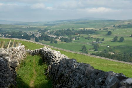
Click image to visit gallery of 12 images.
This is a delightful Yorkshire Dales walk that introduces you to many of the characteristics of this National Park. The start is the village of Linton (grid ref. SD996627) where on street parking is available. Do remember not to cause inconvenience for residents and park considerately.
To start, walk upstream along the Linton Beck with the stream on your right. At grid ref. SD997625 turn left onto a signed footpath. The path bypasses some buildings before joining a track. Keep straight ahead ignoring paths coming in from the right and left and continue across fields to reach Thorpe Lane (grid ref. SE005620). Go left along this quite lane to a T-junction. Go right here and bear left in the centre of the village. Continue along this lane to the point where the lane goes left. Take the signed walled lane towards Burnsall to cross a track marked 'Badger Lane' on OS maps. At the end of the first field after this track, the path veers to the right (grid ref. SE027616). The path then crosses a number of narrow fields eventually reaching the main road in Burnsall (grid ref. SE032612).
There are refreshments available in Burnsall and its worth having a look at the River Wharfe and the substantial Burnsall Bridge. The next section of the route follows the Dales Way alongside the River Wharfe. Initially the path is on the west bank (river on your right) but crosses to the east bank at a rather grand suspension bridge (grid ref. SE025623). Reaching the other side the walk continues across pleasant riverside grass - this is a delightful stretch of the River Wharfe - and takes you to the stepping stones close to Linton Church (grid ref. SE006631).
You do have the option of crossing the river here but the stepping stones can be very slippery. If you do cross here you can continue to Linton Church where you will join the walk once more. Assuming you have decided for a safer (and possibly drier!) option continue along the east bank of the River to reach Sedber Lane (grid ref. SE001633). Close by are the Linton Falls which are weirs across the Wharfe.
Turn left onto Sedber Lane and walk down to the road. Turn left and continue towards Linton Church, which is worth a visit. The village of Linton was not really that convenient for churchgoers as you are about to discover! Having visited the church, retrace your steps up the lane and take the footpath on the left (grid ref. SE002631). Almost immediately the path divides. Bear right and follow the path to the main road. Turn right and then fork left and you will soon be back in the centre of Linton village.
Other walks nearby
| Walk 1145 | Grassington, Mastilles Lane & Conistone Dib | moderate | 11.3 miles |
| Walk 1645 | Grassington, Mastilles Lane & Conistone Dib | moderate | 12.0 miles |
| Walk 1846 | Garnshaw House & Linton Falls from Grassington | easy | 3.0 miles |
| Walk 2610 | Hebden Gill & Cupola Corner | easy/mod | 6.5 miles |
| Walk 2611 | Hebden Gill from Hebden | easy | 4.0 miles |
| Walk 1576 | Embsay Reservoir | easy | 1.0 miles |
| Walk 1280 | Trollers Gill | moderate | 9.0 miles |
| Walk 2000 | Wharfedale Circular | moderate | 13.5 miles |
| Walk 1701 | Bordley Hall & Malham Moor from Threshfield Moor | easy/mod | 7.0 miles |
| Walk 3109 | Rylstone Edges & Cracoe from Rylstone | easy/mod | 6.0 miles |
Recommended Books & eBooks
The Dales Way
 An essential guidebook to walking the Dales Way. This picturesque 78 mile long distance route through the Yorkshire Dales between Ilkley and Bowness on Windermere is one of the gentlest multi-day walks in Britain. The route is described in both directions, visiting Grassington, Kettlewell, Buckden, Dent, Sedbergh and Staveley en route to Bowness.
More information
Trail and Fell Running in the Yorkshire Dales
 Guidebook to 40 of the best trail and fell runs in the Yorkshire Dales National Park. Ranging from 5 to 24 miles, the graded runs start from bases such as Ribblehead, Dent, Sedbergh, Malham and Grassington and take in the region's diverse delights, from castles and waterfalls to iconic mountains such as Whernside, Ingleborough and Pen Y Ghent.
More information
Messaging & Social Media
Message Walking Britain and follow the latest news.

Mountain Weather
Stay safe on the mountains with detailed weather forecasts - for iOS devices or for Android devices.