Ben Arthur ("The Cobbler") Walk
Walk 1459 - Route Maps & Profile
Route Map
Digital Maps - Copyright © 2011-2024. All rights reserved.
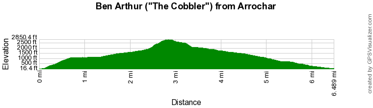
Route Profile
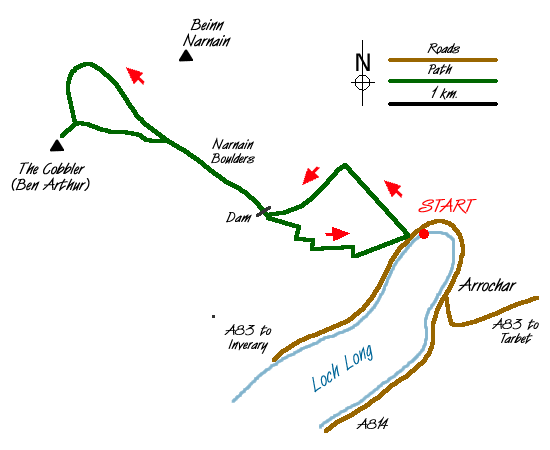
Sketch Map
Suggested Maps 

| Ordnance Survey Explorer OL39 | Sheet Map | 1:25k | BUY |
| Anquet OS Explorer OL39 | Digital Map | 1:25k | BUY |
| Ordnance Survey Landranger 56 | Sheet Map | 1:50k | BUY |
| Anquet OS Landranger 56 | Digital Map | 1:50k | BUY |
It is recommended you take a map. The preferred scale is 1:25k.
Start Point Details
Ordnance Survey Grid Ref NN294048
Latitude 56.205122 Longitude -4.751878
Postcode G83 7AP
what3words start tickets.swerving.lifestyle
Walk description may contain detailed information on the start point for this walk.
Further Information
Loch Lomond and Trossachs
Walking in the Loch Lomond and the Trossachs National Park, which covers some 720 sq miles (1,865 sq km), offers some of the finest scenery in Scotland. Inaugurated in 2002, this National Park lies within an hour's drive of 70% of Scotland's population. From rolling lowland landscapes in the south to high mountains in the north, there are many lochs and rivers with forests and woodlands adding variety to the landscape. Today it is a working landscape and there is much of interest charting past mans' activities. Loch Lomond and Trossachs Walking Guide
Walk grading - Learn how each walk is assessed and select a walk to suit your ability and experience by going to Walk Grading Details.
Messaging & Social Media
Message Walking Britain and follow the latest news.

Mountain Weather
Stay safe on the mountains with detailed weather forecasts - for iOS devices or for Android devices.