Walk 1486 - printer friendly version
Harry Hut, Mill Hill & Doctor's Gate from Glossop Walk
Author - Andy Chaplin
Length - 11.3 miles / 18.4 km
Ascent - 1850 feet / 561 metres
Grade - moderate
Start - OS grid reference SK034907
Lat 53.413099 + Long -1.9503146
Postcode SK13 6JY (approx. location only)
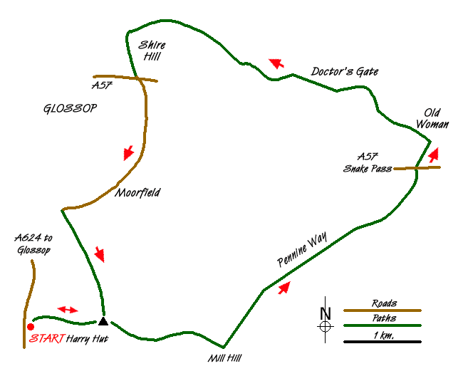
This Peak District walk, to the east and south of Glossop, has one of the best "revealed" views as you come to the top of Doctor's Gate and look down the Shelf Brook Valley. The route is a 'loop on a stick' walk taking advantage of the ample car parking at grid reference SK034907 beside the A624 south of Glossop and the after-walk proximity of the Grouse Inn.
Start from the lay-by on the A624 near the Chunal Plantation then cross the wall stile and go up the hill on the well defined path to the gate in the wall from where the path continues up Chunal Moor to the Harry Hut trig point. There are views off on the left to Glossop and to the north you can see Holme Moss. Take the path that leads off to the right. There is the choice of the path or a mown moors track on its left, both of which come out on the flagged path that leads from the Grouse Inn to Mill Hill. On your way you pass the remains of a B-24J Liberator that crashed on the 11th October 1944.
Turn left at Mill Hill on the paved path that is indicated with the "Pennine Way" marker on the stone in the middle of the path. The path is paved all way to the A57 and you can tell where you are heading as you can normally see cars parked at the top of the Snake Pass. As you set off from Mill Hill there are views off to the right down the Ashop valley with the Kinder Scout ridge above it.
It is easy walking to the A57 although the paved path does take a fairly wide loop towards the end in order to avoid several small cloughs. Cross over the A57, go through the gate and along the path on the opposite side onto Hope Woodlands Moor. This is an odd name as it's not near Hope, doesn't have any woodlands and doesn't seem to appear on the OS maps. In the dip at Old Woman turn left down the Doctor's Gate path and just before Urchin Clough you get "the view".
Allegedly this is the course of a Roman Road but the Roman?s are as likely to get a cart up the road as you are to be able to drive up the Mam Tor road. Anyway, as you walk down the path the upside is the view along the valley; the downsides are the steep drop down at the side of the path as you cross Urchin Clough, the boggy patches as you get to Birchen Orchard Clough and the footbridge (minus a lot of slats in 2014) over the Shelf Brook. As you get further down there is a higher path away from the brook that avoids some later boggy patches.
As you come to the end of the valley the path becomes a track, passes the farm barn on your right and comes down to the bridges at the Yellowslacks and Shelf Brooks confluence near Mossy Lea Farm. Turn right at this point, taking the bridleway to Glossop and pass the clay shooting on your right. Just before you get to the factories at the Mill Pond, take the path on the left on the bridge over the stream and up the side of Shire Hill.
You can go either side of the Shire Hill Wood boundary wall as the paths both join up again further down. Keep the field fence on your right then, when you see the playing field/recreation ground, start to bear left through the estate, coming out on Queens Drive onto the A57.
Cross the road at the Royal Oak pub and follow the minor road past the Golf Club. It starts with pavements, then narrows but finally opens up again as you go uphill then around the corner at Hurst End Farm. Carry straight on at the junction at Moorfield and take the second footpath off on your left when you have passed Gnat Hole Farm.
This path goes up the ridge of the Shaw Moor plantation. The path is well defined all the way up to a gate in the wall on the horizon. When you go through this gate you then have the Worm Stones on your left. Keep climbing up the gritstone path up the hill. You can see the valleys off to the left, along with the Shooting Cabin that will always be off on your left. There is a mown moors track on your right and both this and the footpath lead up to Harry Hut trig point.
Hopefully you should remember this and therefore work out that you take the path on the right to make your way back to the parking place which becomes visible as you get closer to the A624.
Messaging & Social Media
Message Walking Britain and follow the latest news.

Mountain Weather
Stay safe on the mountains with detailed weather forecasts - for iOS devices or for Android devices.