Helvellyn & Fairfield Horseshoe from Patterdale
Lake District Walk
Nat Park - Lake District - Lake District Eastern Fells
Wainwrights - Catstycam, Dollwaggon Pike, Fairfield, Helvellyn, Nethermost Pike, St Sunday Crag
County/Area - Cumbria
Author - Stephen Starkey
Length - 13.0 miles / 21.1 km Ascent - 5280 feet / 1600 metres
Time - 11 hours 50 minutes Grade - very hard
Maps 

| Ordnance Survey Explorer OL5 | Sheet Map | 1:25k | BUY |
| Anquet OS Explorer OL5 | Digital Map | 1:25k | BUY |
| Ordnance Survey Landranger 90 | Sheet Map | 1:50k | BUY |
| Anquet OS Landranger 90 | Digital Map | 1:50k | BUY |
Walk Route Description
Click image to see photo description.
NOTE : In Summer conditions, this is a very hard Lake District walk, involving over 1,500m of ascent in 21km. In Winter it is a severe route only to be undertaken by people experienced in Winter mountain walking, carrying all the right equipment and preferably in good conditions. Nonetheless, it is a very rewarding Winter day out.
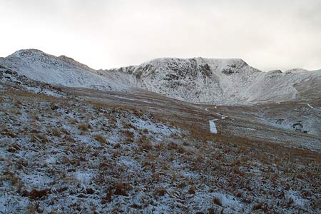
From the village of Patterdale (Grid ref NY395159), take the footpath to the right of the public toilets and follow this through Glenamara Park for about 1.7km until, just after crossing a wall above Thornhow, a path leads off down hill to the right. Take the path to the right, which shortly meets a minor road. Cross the road and take the access lane towards the kennels. When the lane bends round to the right, pass through the gate ahead for the path uphill through the field. At the top of the field, pass through another gate and then turn left on an obvious, well trodden path that steadily climbs across the slopes of Birkhouse Moor. Although never particularly steep, this is a long steady but energy sapping climb out of the Grisedale valley that should not be underestimated. The path eventually arrives at The Hole In The Wall which makes a good point for a short rest whilst admiring the views and contemplating what lays ahead.
For this particular route, what lays ahead is to leave the masses at this point and take the path that leads to the North of Red Tarn. It is not unusual to be able to enjoy the views here in splendid isolation whilst watching the "army of ants" heading across Striding Edge by any number of routes. After rounding the side of Red Tarn, the path starts to climb steadily once again but the spectacular views of Helvellyn are never lost (mist permitting !).
When approximately level with the Western end of Red Tarn, look out for a path joining from the right as this is the path we double back on to in order to summit Catstye Cam. This peak is all too often bypassed or ignored by the masses who set out to bag Helvellyn and they don't know what they are missing. The summit of Catstye Cam provides a stunning place for a brew whilst drinking in the spectacular views of the Helvellyn horseshoe. On a clear day, turning round to look the other way will reveal extensive views across the Cumbrian Moors and out to the Pennines.
Having got your breath back, descend from Catstye Cam back towards Helvellyn which is summited via Swirral Edge. For those who are slightly nervous, as well as the path up the rocky edge, there is an alternative, easier path to the left of the ridge though it should be noted that this path is not exempt from moments of exposure. For those who take the ridge path, it is worth noting that although Swirral Edge does not have the fame or reputation of Striding Edge on the other side of Red Tarn, there are still a large number of Mountain Rescue call outs to accidents on Swirral Edge. As always, treat the mountains with respect.
Reaching the top of Swirral Edge, turn left for the short, easy walk to the cairns atop the plateau summit of Helvellyn. Anybody climbing Helvellyn in winter needs to take care to stay well back from the edge as helvellyn is notorious for snow / ice cornices overhanging the rock face. Those seeking solitude are unlikely to find it at the top of England's third highest and most popular peak. It is worth wandering around the summit to seek out the Gough Memorial Stone and also the plaque commemorating the first mountain top landing by an aircraft in the UK before heading past the oft photographed viewpoint of Striding Edge on the way towards Nethermost Pike.
Leaving the summit of Helvellyn, our route follows the path via Nethermost Pike and Dollywagon Pike. Whilst walking this ridge, there are a series of spectacular views back down Grisedale to the left and some care is needed with the navigation to avoid taking one of the paths to the right that will lead down to Thirlmere and a very expensive taxi ride back to Patterdale. The descent from Dollywagon Pike needs to be treated with care - some areas are still badly eroded, others have undergone a footpath maintenance programme. This is effectively installing a stone stair case but the stones can be lethally slippery when wet.
From the foot of Dollywagon Pike, take the track to head West around Grisedale Tarn. From the tarn, there is an excellent path back down Grisedale as an escape route back to Patterdale for those starting to run low on energy. For those who want to continue, we climb away from the tarn towards Grisedale Hause and the looming slopes of Fairfield.
From the hause on a clear day you are afforded spectacular views to the West across Grasmere Common, the Langdale Fells and to the Scafell Massif beyond before setting out on the unrelentingly steep ascent of Fairfield's Western slopes. As well as being steep, the path is also rocky with loose scree in places. Care is needed when navigating the route off the summit of Fairfield, especially in mist, as there are marker cairns in just about every direction you look.
Leaving the summit of Fairfield, you need to take the path on a grid bearing of 350 for a steep and rocky descent of Cofa Pike to Deepdale Hause before climbing the path on the other side of the hause up the South West shoulder of St Sunday Crag. Although there is a clearly defined path across the brooding bulk of St Sunday Crag, it is often worth meandering a little along the top to take in any number of a wealth of superb views.
After starting the descent of St Sunday Crag, look out for a grass path leading off to the right from the main track at grid ref NY375142. Take the grass path and follow across moorland that can often be wet underfoot to take in the secondary summit of Birks from where we descend East through the crags to pick up a path leading around Trough Head and Hag Beck then up to Arnison Crags.
Although the lowest summit on the route, the views from here are worth the effort. A clear path descends from Arnison Crags through Oxford Crag alongside a wall to eventually meet our outward route where we turn right to return to Patterdale at the end of a tough day amongst some of the best Cumbrian mountains.
Other walks nearby
| Walk 1156 | Helvellyn via Striding Edge | hard | 9.5 miles |
| Walk 1235 | Red Tarn & Grisedale | moderate | 7.0 miles |
| Walk 1710 | Glenridding, St. Sunday Crag & Helvellyn | hard | 11.5 miles |
| Walk 3232 | Glenridding Dodd & Sheffield Pike | easy/mod | 4.5 miles |
| Walk 2327 | Red Tarn & Birkhouse Moor from Glenridding | moderate | 6.0 miles |
| Walk 3668 | Catstye Cam from Glenridding | mod/hard | 7.0 miles |
| Walk 1110 | Angletarn Pikes | moderate | 7.0 miles |
| Walk 2060 | The Angletarn Pikes and Brock Crags from Hartsop | moderate | 8.0 miles |
| Walk 3388 | Hayeswater and Angle Tarn from Hartsop | mod/hard | 11.5 miles |
| Walk 2386 | Red Screes via Dove Crag | mod/hard | 8.6 miles |
Recommended Books & eBooks
Lake District: Low Level and Lake Walks
 This guidebook describes 30 of the best low-level walks in the Lake District. From delightful wooded glades and sparkling tarns, to waterfalls and glacier-carved valleys towered over by craggy mountains. The walks described aim to seek out the best walking that the lower areas of the Lake District have to offer.
More information
Lake District: High Level and Fell Walks
 This guidebook describes 30 graded fell walks on the ridges and high peaks of the English Lake District, the UK's most popular national park. Reaching some of England's finest and highest mountain scenery, this guide leads readers to classic horseshoes and traditional ascents as well as lesser-known routes to quieter summits.
More information
Messaging & Social Media
Message Walking Britain and follow the latest news.

Mountain Weather
Stay safe on the mountains with detailed weather forecasts - for iOS devices or for Android devices.