Walk 1526 - printer friendly version
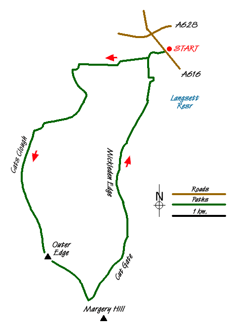
Cats Clough Head & Outer Edge Walk
Author - Andy Chaplin
Length - 9.0 miles / 14.6 km
Ascent - 1100 feet / 333 metres
Grade - moderate
Start - OS grid reference SE201010
Lat 53.50531 + Long -1.698421
Postcode S36 9FD (approx. location only)
The moors to the northwest of Sheffield offer some wonderful Peak District walks with relatively few people on the paths. This route was based on the confirmation that there is a path up Cats Clough and along to Outer Edge as described in a longer walk described by 'Stocksbridge Walkers Are Welcome'.
The walk described here starts near the Flouch roundabout and is initially the same as WB walk 1401. leave the car park by the gate at the south end, cross the road and go down a track through Langsett Woods on Brook House Lane. After 400m, where the main track swings to the left, go down to the right to a signpost at a the junction. Take the path to the right signposted to Swinden keeping the stream on your right and finally leave the woods at a gate. In a further 30m (grid ref. SE193009), go left and then immediately right on to a broad walled bridleway.
Continue along this bridleway then take the right hand route at a junction after a further 200m. This is Swinden Lane which leads to a stile into open country (grid ref. SE184008). Cross the stile and turn left down Hordron Road across the stream and continue following it as it winds across the moors. At a junction (grid ref. SE183997) keep right and continue along Long Moor Edge to a stone barn at Upper Hordron.
Go left and pass below the enclosure around the barn. After 50 m, take the quad track left down the hill. As you go over the ridge you will be able to see the bridge over the stream to the right. Follow the track down to the bridge. Cross the bridge and the path goes straight up the hill, through the heather, subsequently passing a series of grouse butts as you climb up Cats Clough. As you get closer to the top you also get closer to the stream on your right.
Continue up the hill until you reach the top, with a view across to Rocking Stones. At the marker post, turn left and follow the path up to the trig point at Outer Edge. You will pass two boundary stones, both marked with a 'B' and a series of wooden marker posts.
From the trig point continue along the path in the direction of Margery Hill. As the path starts to rise it meets the old pack horse route, Cut Gate. The intersection of the paths is marked with a pile of rocks. Turn left and follow Cut Gate down towards Langsett Reservoir.
About half way down Bull Clough there is a Peak District & Northern Counties sign (No. 50). Follow the path straight ahead to Floch Inn & Hazlehead. The path comes down to the west end of the reservoir which you cross on the bridge over the Little Don river then continue up into the woods and along the main path back to Brook House lane and across the A616 to the parking.
Messaging & Social Media
Message Walking Britain and follow the latest news.

Mountain Weather
Stay safe on the mountains with detailed weather forecasts - for iOS devices or for Android devices.