Walk 1534 - printer friendly version
Swyre Head & Tyneham Cap from Kimmeridge Walk
Author - Lou Johnson
Length - 11.8 miles / 19.1 km
Ascent - 1400 feet / 424 metres
Grade - moderate
Start - OS grid reference SY918800
Lat 50.619648 + Long -2.1172721
Postcode BH20 5PH (approx. location only)
This walk combines dramatic seascapes with the more rural landscapes in land. The route passes one of Britain's few land based oil wells and includes a section of the South West Coast Path. Sections of this walk are close to firing ranges and you are advised to take heed of all warnings in respect of path closures. In addition it is recommended you stay on marked paths and do not touch any suspicious objects that you might find. There is also restricted access so please check Range Opening Times.
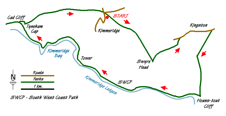
The start is the small car park located in a quarry above the village of Kimmeridge (Grid ref. SY918800). After parking, take the signed bridleway on the northern side of the quarry that rises gently in south-easterly direction along a ridge onto Smedmore Hill. The bridleway continues in a similar direction to the trig point on Swyre Head (203 metres above sea level).
From Swyre head the route initially swings north following a bridleway past Polar Wood to reach a tarmac lane (grid ref. SY943792). Bear right along the lane and walk towards the village of Kingston (where there is a pub slightly off route). Reaching the Plantation car park (grid ref. SY953795) turn right down the signed footpath that leads down to the coast at Houns-tout Cliff.
Reaching the coast turn right along the South West Coast Path. You walk past the Kimmeridge Ledges to reach the Clavell Tower and Kimmeridge Bay. Stay on the South West Coast Path past the oil wells and up to the eastern end of Gad Cliff (grid ref. SY888797). Turn right here and ascend Tyneham Cap continuing by following the track ahead which descends to reach a bridleway at grid ref. SY905802. Here take the bridleway straight ahead which leads back to the car park from where the walk started.
Messaging & Social Media
Message Walking Britain and follow the latest news.

Mountain Weather
Stay safe on the mountains with detailed weather forecasts - for iOS devices or for Android devices.