Walk 1548 - printer friendly version
Rye Loaf Hill from Settle Walk
Author - Lou Johnson
Length - 7.6 miles / 12.4 km
Ascent - 1500 feet / 455 metres
Grade - moderate
Start - OS grid reference SD819637
Lat 54.0689140 + Long -2.2780690
Postcode BD24 9JD (approx. location only)
An energetic walk from the market town of Settle passes through glorious limestone scenery before climbing to the summit of Rye Loaf Hill (1794 feet, 546 metres). Rye Loaf Hill is one of several tops between Settle and Malham and sees few walkers despite the excellent views that can be enjoyed from its summit.
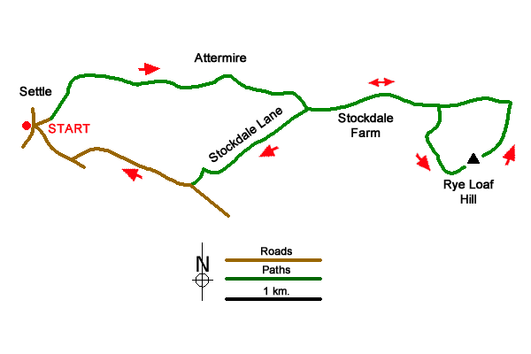
The start is outside the Tourist Information Centre, Market Place, Settle (SD819637). With your back to the entrance to the TIC, turn left and then first left. Bear right passing a row of shops on your right and then turn right up Constitution Hill. Climb steeply and follow the lane as it bends left. When the gradient eases fork right onto a bridleway signed to Langcliffe (grid ref. SD821638). Continue up the path between walls with a pleasant view on the left, over Settle. Continue to a small stone building on the left. Pass through the gate and veer right off the main path on a grassy rising path.
Pass through a gap in a wall and veer right and follow the rising path before losing a little height to reach a gate (grid ref. SD840642) below imposing limestone crags. Continue through the gate, ignore the path left, bear half right, and follow the grassy path for about a kilometre to join Stockdale Lane (grid ref. SD847638). Bear left along the surfaced track and continue towards Stockdale Farm. Just before the farm fork half left through a gate (signed Malham).
Continue along the grassy path through another gate. The path starts to descend passing a gate in the wall on your right. Continue to a second gate in the wall on your right (grid ref. SD861638). Turn right through gate and follow an intermittent feint path with wall on your right. Descend into a gully (with stream after rain) and climb beside the wall Nearing the top bear left over grass to gain the summit of Rye Loaf Hill and enjoy the extensive view.
To continue, descend east and follow a wall down (right) down to gate. Continue ahead to regain Stockdale Lane (grid ref. SD868639). Turn left and retrace your steps past Stockdale Farm to join the tarmac lane. Stay on the tarmac passing the point where you joined the lane earlier in the walk. Follow the lane left and continue downhill to reach High Hill Lane (grid ref. SD836630). Turn right and continue down Albert Hill into Upper Settle. Continue along Victoria Street keeping left over cobbles at the first fork. Pass The Museum of Craven Life on your right and then take the next street on the right (High Street) which leads you back to the start.
Retrace your steps to the metal gate. Cross a stile with three public footpath markers indicated (grid ref. SO689675). Go straight across the field ignoring the path on the left and the path heading half right. Follow the middle route across a field aiming for a gap in the hedge opposite (grid ref. SO791674) and into another field. Continue in the same direction with the hedge soon on your right. Passing ornamental an pond on your left and just before reaching Solhampton Farm, turn right along an enclosed bridlepath (grid ref. SO795674). Continue along this path, ignoring another route climbing uphill to the right (at grid ref. SO795669). Reaching a brook, turn left and follow the path back to the B4196 main road. Turn right along the main road and return to the New Inn and car park.
Messaging & Social Media
Message Walking Britain and follow the latest news.

Mountain Weather
Stay safe on the mountains with detailed weather forecasts - for iOS devices or for Android devices.