Walk 1555 - printer friendly version
Brunt Knott from Staveley Walk
Author - Lou Johnson
Length - 7.0 miles / 11.4 km
Ascent - 1600 feet / 485 metres
Grade - easy/mod
Start - OS grid reference SD469980
Lat 54.374722 + Long -2.8189234
Postcode LA8 9NE (approx. location only)
This walk on the periphery of the Lake District explores the landscape to the northwest of Staveley and includes an ascent of one of the Outlying Fells, namely Brunt Knott. This route is far removed from the busier routes around the major honeypots of the Lake District National Part. Due to its nature a decent map and some navigation skills are required.
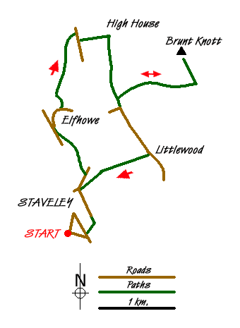
For convenience's sake the route is described from the railway station in Staveley (grid ref. SD469980). With your back to the station turn right along The Banks to reach Main Street. Turn left here and in a short distance you will find a footpath (opposite the Post Office) on the right that leads across the River Kent. Once across the river turn left to reach a road (grid ref. SD471984). Continue alongside the river to Barley Bridge. Bear right here and follow the road as far as signed bridleway on the left, which is taken through Scroggs Farm to reach a lane (grid ref. SD466966). Keep straight ahead and take the lane on the right leading up to Elfhowe. Just prior to these farms bear right on a rough track/path (grid ref. SD468988). Keep the wall on your right across a number of walled fields to reach a more substantial track just north of Park House (grid ref. NY470009).
Turn right along this track for a short distance and take the first footpath on your left leading uphill to High House (grid ref. NY474009). Turn right (roughly south) along the track until your reach a junction (grid ref. NY476000). Turn left here climbing to Brunt Knott Farm. Pass the farm and continue uphill with the summit of Brunt Knott ahead and slightly to your left. There are a number of options to reach the summit. You can make a beeline but the ground is steep and fairly rough. The other option is to locate the path which leaves the track at grid ref. NY486001) which makes the ascent much easier.
After enjoying the views from the summit return to Brunt Knott Farm and descend their access track to the junction at grid ref. NY476000, which should be familiar. Turn left here and follow the lane to Littlewood Farm (grid ref. SD480992). Here take the signed footpath to Staveley on your right. Which descends to Barley Bridge. Turn left here along the lane and you will soon be back in Staveley.
Messaging & Social Media
Message Walking Britain and follow the latest news.

Mountain Weather
Stay safe on the mountains with detailed weather forecasts - for iOS devices or for Android devices.