Walk 1566 - printer friendly version
Isle of Scalpay circular, Harris Walk
Author - Andy Chaplin
Length - 5.3 miles / 8.5 km
Ascent - 500 feet / 152 metres
Grade - easy
Start - OS grid reference NG216972
Lat 57.877155 + Long -6.6976853
Postcode HS4 3XZ (approx. location only)
A longer version of this five mile walk is available at Walk Highlands at www.walkhighlands.co.uk/outer-hebrides/isle-of-scalpay.shtml. There are also other versions that shorten the walk in the reviews. The weather can alter so quickly in Harris it is good to have ways of getting back to the start point before visibility goes and/or you are completely soaked.
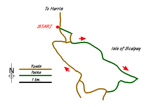
Having crossed on the bridge from Harris, turn first left, and park opposite the storage area in the tarmac bay off the road (grid ref.NG216972). Walk eastwards towards the stone quarry building and at the road junction turn right and continue past the track that leads to the house called Woodstock. At the next 3 houses turn left through the metal farm gate to follow the surfaced lane towards the fourth house. Turn right in front of it and go through a gate onto a track which heads left to Loch an Duin. Go left over a stile and footbridge and follow the path around the north of the loch.
From this point there are marker posts and it is possible to see the next one where the path is difficult to see in the boggy ground. They are numbered in reverse order. When you reach a fence pass through the gates and continue following the posts to the far end of Loch an Duin. Climb uphill from the stream and follow the posts which pass to the south of Loch Cuilceach.
The route leads up to Beinn Scorabhaig from which, in good weather, there are good views over the mountains of Harris. The Eilean Glas lighthouse is directly ahead and the path aims for it. At this point you can also see the new stone track on your right that leads to the lighthouse from Kennavay and it is at this point that I left the way-marked path and headed for the new stone track.
The track heads into Kennavay where it joins the road where you turn left and follow it, ignoring the side roads and continue northwards until you reach the main settlement on Scalpay. There is a community shop and café here, that is well worth the stop. Continue over the bridge at the head of Ceann a Bhaigh and follow the signs back to the Scalpay bridge and the car parking.
Messaging & Social Media
Message Walking Britain and follow the latest news.

Mountain Weather
Stay safe on the mountains with detailed weather forecasts - for iOS devices or for Android devices.