Sandridge, Coleman Green & Brocket Hall Circular Walk
Walk 1607 - Route Maps
Route Map
Digital Maps - Copyright © 2011-2024. All rights reserved.
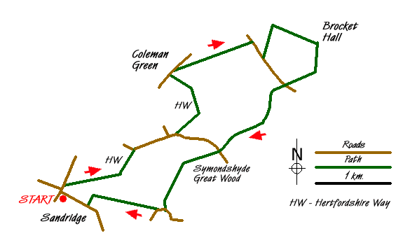
Sketch Map
Suggested Maps 

| Ordnance Survey Explorer 182 | Sheet Map | 1:25k | BUY |
| Anquet OS Explorer 182 | Digital Map | 1:25k | BUY |
| Ordnance Survey Landranger 166 | Sheet Map | 1:50k | BUY |
| Anquet OS Landranger 166 | Digital Map | 1:50k | BUY |
It is recommended you take a map. The preferred scale is 1:25k.
Start Point Details
Ordnance Survey Grid Ref TL169104
Latitude 51.780065 Longitude -0.306859
Postcode AL4 9DD
what3words start piper.remove.tree
Walk description may contain detailed information on the start point for this walk.
Further Information
Hertfordshire
Despite its proximity to London, Hertfordshire offers a wide range of walking opportunities through pleasant countryside and attractive villages. Hemel Hempstead, Stevenage, Watford and St Albans are the main towns with walks to suit all abilities within easy reach. The highest land in the county lies to the north-west at Pavis Wood near Tring (244 metres above sea level). Part of the county lies within the Chilterns National Landscape (formerly AONB) and is characterised by rolling hills offering scenic walks. Long distance footpaths in the county include the Ridgeway, Icknield Way, Harcamlow Way, Hertfordshire Way and the Grand Union Canal Walk.
Walk grading - Learn how each walk is assessed and select a walk to suit your ability and experience by going to Walk Grading Details.
Messaging & Social Media
Message Walking Britain and follow the latest news.

Mountain Weather
Stay safe on the mountains with detailed weather forecasts - for iOS devices or for Android devices.