Grassington, Mastilles Lane & Conistone Dib
Yorkshire Dales Walk
Nat Park - Yorkshire Dales - Upper Wharfedale
County/Area - North Yorkshire
Author - Peter Schofield
Length - 12.0 miles / 19.5 km Ascent - 1950 feet / 591 metres
Time - 8 hours 0 minutes Grade - moderate
Maps 

| Ordnance Survey Explorer OL2 | Sheet Map | 1:25k | BUY |
| Anquet OS Explorer OL2 | Digital Map | 1:25k | BUY |
| Ordnance Survey Landranger 98 | Sheet Map | 1:50k | BUY |
| Anquet OS Landranger 98 | Digital Map | 1:50k | BUY |
Walk Route Description
Click image to see photo description.
Grassington is the main village in the lower reaches of Wharfedale in the Yorkshire Dales National Park. Retaining much character, despite the gift shops, the village almost has the feel of a town. This is a long walk but there is so much to see and enjoy that the miles pass quickly. The ascent is easy and especially in Consitone Dib passes almost unnoticed.
This route is based on walk 1145 but avoids the section of road walking at the start. This adds just under a mile of extra walking a little more ascent but does avoid the majority of the road section.
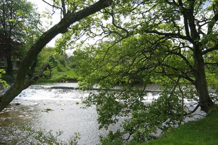
The easiest place to park for this Yorkshire Dales walk is on the large car park adjacent to the National Park information centre (grid ref. SE 002637). Leave the car park by the south entrance and follow Sedber Lane down to Linton Falls. Cross the bridge and follow the path around the houses to reach a lane.
Turn right and follow the lane for 200m to a junction. Turn right again and after a further 200m, Threshfield School is reached where you turn left on to a footpath. The school was established in 1674 and its 300th anniversary is commemorated on a stone over the door. Follow the path for about 600m over fields and an old railway bridge to reach the B6160 at a stile.
Turn right and after 100m, turn left into a lane which leads to the delightful village green at Threshfield where the old village stocks can still be seen. Cross the B6265 and take a waymarked path to the right of the Old Hall pub which crosses a number of fields and stiles, finally reaching Skirethorns Lane at the bridge over Spiredale Beck.
Turn left and follow this lane, turning right into Wood Lane. The end of the road walking is now in sight. Turn left up the main drive into the Caravan site at Wood Nook continuing through the site to emerge alongside Rowley Beck.
The true nature of the countryside is now evident with outcrops of limestone becoming more frequent. Climbing slowly Height House, an abandoned farm, is soon reached and the path continues westwards to Height Laithe Farm which nestles in the valley.
Care is needed in this area as there are a number of paths near the farm although the next objective, Bordley, is signed. The path loses height quite quickly as it approaches Bordley. Reaching the farm access road turn right along it regaining lost height as you head north. Dropping slightly you reach a hollow. Here you leave the road and follow the wall north to Mastilles Lane to Mastilles Gate.
Turn east along the well graded walled lane. You cross wild country - limestone uplands as you cross Kilnsey Moor. Quite suddenly the view ahead opens up across Wharfedale to Great Whernside. You can also clearly see the defile of Conistone Dib immediately behind the village.
With an easy downhill walk you can admire the views staying on the lane until you are under Cool Scar. On the right is a well disguised stile (grid ref. 968673) which leads onto a path down to Bow Bridge Farm. Left on to the main road and right over the Wharfe into Conistone. It is worth looking north from here to the impressive outcrop known as Kilnsey Crag - apparently well favoured by climbers.
A pleasant unspoilt village (no refreshments were found) with cottages grouped together around the small village "green". Leave the road and take the path heading east. This follows the floor of Conistone Dib, a classic limestone gorge, climbing slowly to reach the limestone plateau above. The last section is an easy scramble but should not cause any problems. On reaching the plateau turn immediately right. Do not go through the gate, and follow this path south, ignoring paths descending right.
You are now on the Dales Way (poorly signed in this area) which needs to be followed all the way back to Grassington. To your right and left are excellent examples of limestone pavements. They are very extensive in this area and are certainly equal to those found above Malham. The path splits roughly half way to Grassington (grid ref. SD 996663). The best route is to stay with the wall on your left which eventually leads into a walled lane. Soon you are back in Grassington.
Other walks nearby
| Walk 1292 | Linton & Thorpe Fell & Cracoe | moderate | 9.0 miles |
| Walk 1407 | Thorpe & Burnsall from Linton | easy/mod | 6.2 miles |
| Walk 2610 | Hebden Gill & Cupola Corner | easy/mod | 6.5 miles |
| Walk 2611 | Hebden Gill from Hebden | easy | 4.0 miles |
| Walk 1280 | Trollers Gill | moderate | 9.0 miles |
| Walk 2000 | Wharfedale Circular | moderate | 13.5 miles |
| Walk 1576 | Embsay Reservoir | easy | 1.0 miles |
| Walk 3301 | Conistone to Grassington via the Dib | easy | 5.0 miles |
| Walk 3262 | Copplestone Gate and Conistone Pie from Conistone | easy/mod | 7.0 miles |
| Walk 2423 | Capplestone Gate & Conistone Pie | easy/mod | 6.8 miles |
Recommended Books & eBooks
Walking in the Yorkshire Dales: North and East
 This guidebook contains 43 circular day walks in the north and east Yorkshire Dales. It explores the dales, hills and moors between Kirkby Stephen and Pateley Bridge. Walking ranges from gentle 3 mile strolls to more strenuous day-long rambles across the Howgills, Wensleydale, Swaledale, Nidderdale, Mallerstang and Coverdale.
More information
Walking in the Yorkshire Dales: South and West
 Part of a two-book set, this guidebook describes 44 walks in the southern and western Yorkshire Dales, including the famous 23 mile Three Peaks circuit over Pen-y-Ghent, Whernside and Ingleborough. The other, mostly circular routes of 3½ to 13 miles cover the scenic region between Sedbergh, Kirkby Lonsdale, Settle, Skipton and Grassington.
More information
Messaging & Social Media
Message Walking Britain and follow the latest news.

Mountain Weather
Stay safe on the mountains with detailed weather forecasts - for iOS devices or for Android devices.