Walk 1653 - printer friendly version
The Manifold Valley from Wetton Walk
Author - Lou Johnson
Length - 7.8 miles / 12.7 km
Ascent - 1000 feet / 303 metres
Grade - easy/mod
Start - OS grid reference SK108553
Lat 53.094799 + Long -1.8401749
Postcode DE6 2AF (approx. location only)
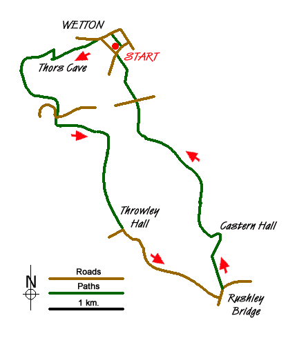
This is one of the great Peak District walks in the Staffordshire sector of the National Park Starting from the small car park in Wetton (grid ref. SK108553) where there are toilets. The route takes in Thor's Cave, the Manifold Trail, the limestone outcrop of Beeston Tor, Throwley Old Hall, and Castern Hall. The walk is notable for the excellent views throughout the route. Refreshments are sometimes available near Weags Bridge and there is a pub in Wetton.
Exit the car park using the stone stile at the rear of the car park. There is no footpath sign but walk north across the field to a lane. Turn left along the lane and continue until you reach a track on your left (grid ref. SK106552) signed for Thor's Cave. You soon get a good view up the Manifold Valley. Continue to Thor's Cave taking the lower path where it divides. From Thor's cave the path descends steeply on steps into the Manifold valley. Cross the footbridge over the usually dry bed of the River Manifold and turn left. Continue along the old narrow gauge railway, crossing a tarmac lane at Weags Bridge.
After the bridge take the right hand track and follow this for some 500 metres until you reach a stile in the fence on your left. Cross this and continue along the farm track passing a camp site with Beeston Tor on your left. At the farm bear right up a rising track. This leads gently uphill passing a derelict barn on your left to a gate with a nice cast-iron footpath sign. Go through the gate and go half left across the field walking uphill over grass towards the skyline. The route is not too obvious but you can usually see a feint path in the grass. Continue through the field boundary and descend to Throwley Hall Farm aiming towards the middle of the buildings where there is a gate. Continue through the farmyard and join the tarmac lane bearing left and downhill.
You pass the remains of Throwley old Hall on your left. Continue down the lane with a superb view of the Manifold Valley ahead. Continue down to Rushley, where you go left across the narrow stone bridge over the River Manifold. Once across the bridge take the first footpath on your left and go through fields to join the access road to Castern Hall. You can either bear left along this road or take the short cut by following the footpath which cuts off the corners in the road. Walk past the main entrance to Castern all and follow the track to the right of the buildings. This leads you to a track which goes left and into a field. Follow the grassy track with a wall on your left. Enter another field and continue north to enter a large field which slopes away to the left.
The clear path up this field leads to a stile. Ignore the stile instead walk along the wall (with the wall on your right) towards the valley. This leads to a continuing footpath (not shown on maps) that follows the rim of the valley northwards. Stay on this path for about a mile until you reach Larkstone Lane (grid ref. SK111544). Cross the lane and take the footpath opposite. This leads past a stone barn on your left into another field. Go half right across this field. Before you reach the stile in a cross wall, bear left towards the field corner where another stile leads you onto Carr Lane. Go right along the lane and the car park is a short distance ahead.
Messaging & Social Media
Message Walking Britain and follow the latest news.

Mountain Weather
Stay safe on the mountains with detailed weather forecasts - for iOS devices or for Android devices.