Walk 1657 - printer friendly version
Huntingdon Warren & Lud Gate from Scorriton Walk
Author - Lou Johnson
Length - 7.0 miles / 11.4 km
Ascent - 1500 feet / 455 metres
Grade - moderate
Start - OS grid reference SX703684
Lat 50.5009970 + Long -3.8301950
Postcode TQ11 0JB (approx. location only)
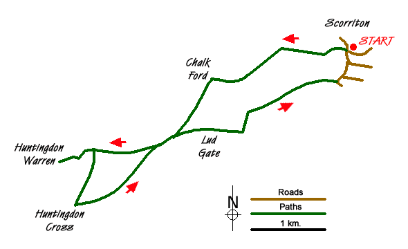
This walk onto the south-western moors of Dartmoor requires some careful navigation and a good sense of direction. The walk starts in the village of Scorriton (grid ref. SX703684) where there are limited parking opportunities. Do be considerate and park carefully. The route uses a section of the arduous Two Moors Way which does provide some reliable signage. It is strongly recommended you have a copy of the OS 1:25000 map.
From the village take the Two Moors Way west along a lane to Chalk Ford (grid ref. SX684680) where open moorland lies ahead. There are a number of stream crossings on this route so care is needed especially if there has been heavy rain recently. From this point the Two Moors Way heads roughly southwest to join a track at grid ref. SX678672 that comes west from Lud Gate. Bear right along this track and continue west to the bridge over Western Wella Brook (grid ref. SX667670).
It is worth walking up to the cairn on top of Huntingdon Warren to enjoy the views before returning to the footbridge mentioned in the previous paragraph. The next part of the route follows Western Wella Brook south to Huntingdon Cross (grid ref. SX664662). There is a feint path on the eastern bank of the brook.
At Huntingdon Cross it is important to get your bearings. You need to take the Two Moors Way which heads just north of east from the cross. The path is generally clear although care is required to keep on course. This path leads back to the track from Lud Gate (grid ref. SX676671) which was used for part of the outward route.
Bear right along this track to Lud Gate and continue along a track towards the Strole. Take the footpath on the left (grid ref. SX688673) leading initially north. The path descends towards Scae Wood becoming a walled track. Follow this past Higher Coombe to reach a lane. Turn left along the lane through Coombe following the lane up to Scorriton.
Messaging & Social Media
Message Walking Britain and follow the latest news.

Mountain Weather
Stay safe on the mountains with detailed weather forecasts - for iOS devices or for Android devices.