Walk 1701 - printer friendly version
Bordley Hall & Malham Moor from Threshfield Moor Walk
Author - Allan Friswell
Length - 7.0 miles / 11.4 km
Ascent - 900 feet / 273 metres
Grade - easy/mod
Start - OS grid reference SD955619
Lat 54.053038 + Long -2.0702276
Postcode BD23 6ND (approx. location only)
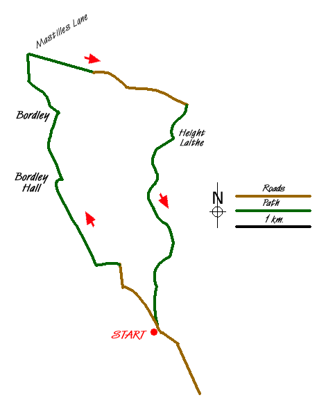
This Yorkshire Dales walk explores Malham Moor and the limestone country in the vicinity of Bordley. To reach the start take the B6265 Skipton to Grassington Road as far as Rylstone where you turn west for Hetton. At the T junction in turn right and then immediately left at the fork. Go down this narrow lane for 1 1/2 miles and park on this old quarry site on the right (Grid ref. SD955619).
Exit the quarry and walk north along the lane towards Bordley to reach the telephone box and farm at Lainger. Leave the lane by the far track on the left which runs alongside a beck to cross the main beck at the bottom. Take the stile on the right and follow Bordley Beck upstream, over another stile and then across to a gate to the left of a small group of trees. From the gate, head across the often boggy reed pasture high above the beck. Ahead is the isolated farm of Bordley Hall. Keep ahead up hill and down boggy dale till you reach the right hand corner, where you cross the beck and then the step stile.
Follow the right hand wall (Grid ref. SD942364), until you come level with the farm buildings when a bridge takes you over the beck and to a bubbling spring where you turn right. Follow the track to a gate behind all the buildings (Grid ref. SD941639). Turn left, climbing the steep field to a gate. In the large field behind, pass through a gate which appears in the top wall. With the gradient easing head half-right to locate a hidden stile in the corner (Grid ref SD940644). Go straight ahead through two gates, then turn sharp right, drop down to the gate by the power lines, turn left, negotiate two more gates and find yourself on a track between Bordley House Farm and Bordley Green Farm.
Turn left in the hamlet and make your way up to the left hand gate at the end of the track. A clear track heads away from the gate, but in a few yards take a lesser track right, following the right hand wall; at a wall-corner ignore the wall as it falls away to the right, maintain your line, heading for the corner, a gate, a finger post and an odd sign (Grid ref. SD937657). Turn sharp right after the gate making for Threshfield. Follow the right hand wall, eventually reaching a crossroads of paths where you keep ahead up the tarmac arm. The lane becomes enclosed, with a recently constructed beautifully crafted 200 yard stretch of drystone walling - simultaneously new and medieval - on your left, facing the ancient moss-covered wall on the right. Follow it for ½ mile to the point where signposts indicate a junction right with a bridle path (Grid ref..SD960650).
From the gate on the right follow a level and outstandingly maintained track. At another gate we descend more clearly past the barn of Height Laithe. Head along an enclosed way to a gate at the far end. From it a track heads right (grid ref. SD958645) crossing the marshy beginnings of a small beck to rise to a gate in the fence. The track leads across the open Threshfield Moor, again with marker posts assisting. On reaching a wall we are channelled through a pleasant walled green way to the next section of moor. Stay with the right hand wall as far as a gate on to Boss Moor. A clear, if often boggy track leads across the moor, and with Bordley Lane in view, our track avoids it until suddenly you arrive at the old quarries and the car park.
Messaging & Social Media
Message Walking Britain and follow the latest news.

Mountain Weather
Stay safe on the mountains with detailed weather forecasts - for iOS devices or for Android devices.