Walk 1747 - printer friendly version
Oswaldtwistle Moor Walk
Author - Lou Johnson
Length - 6.0 miles / 9.8 km
Ascent - 900 feet / 273 metres
Grade - easy/mod
Start - OS grid reference SD751231
Lat 53.7037310 + Long -2.3786591
Postcode BB4 4AU (approx. location only)
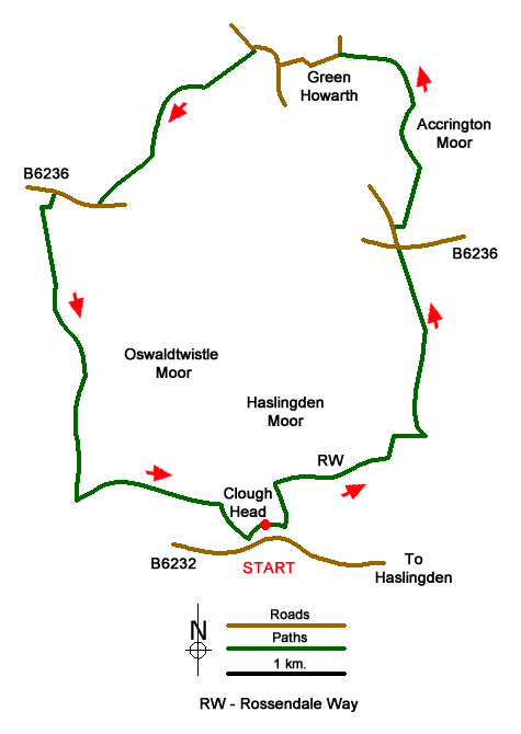
This Lancashire walk explores part of Oswaldtwistle Moor west of the town of Haslingden and includes some of the surrounding countryside. The route is generally easy to follow in fine weather but with low cloud on the moor careful navigation is essential. The start is the car park at Clough Head Visitor Centre (grid ref. SD751231), which has restricted opening hours. Allow at least 4 hours to complete the walk which should be completed by 5 pm in winter and 6 pm in summer to avoid returning to locked gates at the car park.
After parking walk past the front of the cafe along a wide path. After a few metres bear left along the path and continue past the next junction of the left. At the next junction turn sharp left and follow the path towards a strip of woodland. Continue through the wood to reach the Rossendale Way (grid ref. SD752235). Turn right and follow the path past a large quarry on your right, cross the bridge in Deep Clough. Follow the path ahead to reach a second quarry, also on your right. The path bends left and then right to reach a T-junction of paths (grid ref. SD762238). Turn left. The Rossendale Way soon turns right where you keep straight ahead. Follow the rough track up to a gate. You soon see a cairn on the horizon which indicates the route to follow.
Maintain a northerly direction to pass Elmtree Farm on your right and follow their access road to the B6236 (grid ref. SD760250). Take the road opposite and after 150 metres just past Sandy Beds Farm, cross the ladder stile on your right. Go through a gate and walk half left across two small fields using two small stiles. Cross the next field to a ladder stile by an electricity pole (grid ref. SD762255). Once over the stile turn left along a clear track. The track curves to the right across Accrington Moor to reach a track after 600 metres with a golf course on your left. Turn left along the track past the club house car park to exit onto a road (grid ref. SD757263). This road bends right and then left to reach a T-junction at the 'Bowling House'. Turn right and walk down the hill as far as Gaulkthorne House, where you turn left onto a signed public footpath (grid ref SD751263).
Initially the path is enclosed by two walls. On the next section there is a single wall on your right. Continue down to a bridge. Cross the stream and turn right. The path heads uphill to Cockerly Fold where you pass behind a barn, turn left past the front of some houses, bear left through the farmyard to a gate. Follow the path, initially with the field boundary on your right. Maintain direction across a field to reach a wall junction (grid ref. SD744256). Bear half right and follow the path alongside wood (trees on your right) and maintain your direction to a stile in the southwest corner of the field (grid ref. SD740253).
Cross the stile and turn right along the B6236 (Haslingden Road). Reaching the drive to Stoney Knoll Farm (marked with a footpath sign), turn left up the drive and continue past the farm. The track continues alongside a wall on your left. Continue past a disused reservoir on your left (grid ref. SD738246) and continue alongside a wall (on your left). Bear slightly left and continue to another wall corner after 200 metres. Follow the path onto Oswaldtwistle Moor beside the wall (on your left). Continue alongside the wall and maintain a southerly direction where its ends to cross a service track for the wind farm (grid ref. SD739239) and continue to a gate in a fence (grid ref. SD739237).
Once through the gate aim for the marker posts and cairn to reach a ruined building. Drop down to a wall. Turn left onto the path which soon becomes the Rossendale Way. Stay on the clear path for about a kilometre to reach a stile (grid ref. SD749233). Turn left through a small gate a descend the steep path through the wood and back to Clough Head Visitor Centre.
Messaging & Social Media
Message Walking Britain and follow the latest news.

Mountain Weather
Stay safe on the mountains with detailed weather forecasts - for iOS devices or for Android devices.