Walk 1754 - printer friendly version
Agden Reservoir Circular Walk
Author - Andy Chaplin
Length - 4.8 miles / 7.8 km
Ascent - 750 feet / 227 metres
Grade - easy/mod
Start - OS grid reference SK262920
Lat 53.424149 + Long -1.6072003
Postcode S6 6LA (approx. location only)
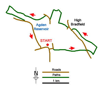
This Peak District walk lies west of Sheffield and starts at the free car park in Low Bradfield on Sands Lane (grid ref. SK262920). Given that it is close to the Agden and Damflask reservoirs it can get busy. An alternative start point would be on the side of the road at grid ref. SK262927 on Smallfield Lane. The highlights of the walk are the views down the Damflask and Agden valleys, Agden reservoir and the fine parish church in High Bradfield.
Assuming that you can park in Low Bradfield, cross the green towards the Postcard Café (or follow the Sands path and road around to it) then go south on Woodfall Lane and off left on Lamb Lane. After 150 meters there is a footpath off to the left which goes behind Mill Farm. This is Bradfield Path No 168 and it angles up the hillside to Loxley Road. There are good views back to Low Bradfield and along the Damflask valley.
Cross the road and take Path No 167 over the wall and along the farm track towards and then below Cliffe House Farm. A little further on you join the Sheffield Country Walk and follow it over Castle Hill to High Bradfield. Head down the road to the Old Horns then Bradfield Church. Pass to the north of the church through the churchyard. Periodically there are flood graves marked off the main path.
At the west end of the churchyard leave the Bailey Hill on your right and take the middle path which goes along the east side of Rocher End brook. When the path comes out to a track follow this over the brook and keep following it until it stops at a point where a path leads down through Rocher End wood. When you get down to Smallfield Lane it is signed as Path No 93.
Turn right on the road (it is here that you could park if it is too busy in Low Bradfield) and continue until there is a permissive path along the north side of the reservoir. The path joins a track south of Sunnyside Farm then continues around the western end of the reservoir. Ignore the footbridge over the Agden or Hobson Moss dike and continue on the track past Agden Bog. The track then goes over Agden dike, past the site of Agden House and then bends left over Emlin dike.
The track comes out on Windy Bank road and from there you continue south along the reservoir to the bus turning circle on Fair House Lane and go left back to the car park on The Sands.
Messaging & Social Media
Message Walking Britain and follow the latest news.

Mountain Weather
Stay safe on the mountains with detailed weather forecasts - for iOS devices or for Android devices.