Walk 1771 - printer friendly version
Ladder Hills Circular Walk
Author - Lou Johnson
Length - 9.5 miles / 15.4 km
Ascent - 1950 feet / 591 metres
Grade - mod/hard
Start - OS grid reference NJ242210
Lat 57.2733320 + Long -3.2586569
Postcode AB37 9JS (approx. location only)
This Ladder Hills walk in Moray walk lies in the northern part of the Cairngorms National Park. The route includes the highest point Carn Mor (804 m.). The walk follows quiet paths across the rounded hills. The route offers some superb views of the Cairngorms as well as the likelihood of seeing some wildlife.
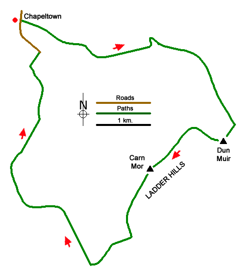
The start is the small East Auchavaich car park (grid ref. NJ242210) in Chapeltown, Glenlivet. From the parking area you have good view of the hills to be explored. After parking follow the tarmac track soon passing a farm on your right. Continue on the track towards the hills. The track soon forks. Bear right and follow the edge of the plantation. Continue past Corrunich, a house on your left, to reach a path/track junction (grid ref. NJ265206). Turn right across a burn, pass through a gate, and stay on the path as it heads up the north side of a glen with Ladder Burn on your right.
The path veers southeast after 800 metres and climbs more steeply drifting higher above the Ladder Burn. Continue southeast to the head of the glen arriving at a broad col (grid ref. NJ281191) which is marked by some cairns. Turn right over rising ground heading initially southwest. Stay on the crest of the ridge along a feint path that swings northwest through wet ground where the path is marked by posts. The route then turns southwest still staying on the crest of the ridge to reach the OS trig. Column on Carn Mor.
Leave the summit by follow the crest of the ridge in a south-westerly direction enjoying the commanding views as you descend. Where the ridge starts to rise, veer slightly right to locate a feint path which soon becomes more obvious and heads southwest. Cross a broad col (grid ref. NJ257168) and veer right up towards a fence. Keeping the fence initially on your left descend the broad ridge. The path crosses the fence to become feint across rougher terrain. Stay with the fence as it veers left (west) and look out for a cairn on your right (grid ref. NJ243176).
From the cairn descend steeply northwest into the valley shadowing the line of grouse butts. Pass through a gate and continue to a group of ruined buildings and a bothy (grid ref. NJ243187). Continue along a grassy track in the valley to reach the College of Scalan. Keep the college on your right and head north to read a tarmac road at West Auchavaich (grid ref. NJ245204). Turn left and return to the start passing a distillery on your left.
Messaging & Social Media
Message Walking Britain and follow the latest news.

Mountain Weather
Stay safe on the mountains with detailed weather forecasts - for iOS devices or for Android devices.