Walk 1772 - printer friendly version
Hurston, Lettaford & Two Moors Way Walk
Author - Lou Johnson
Length - 8.6 miles / 14 km
Ascent - 1100 feet / 333 metres
Grade - moderate
Start - OS grid reference SX676811
Lat 50.6145420 + Long -3.8727649
Postcode PL20 6TA (approx. location only)
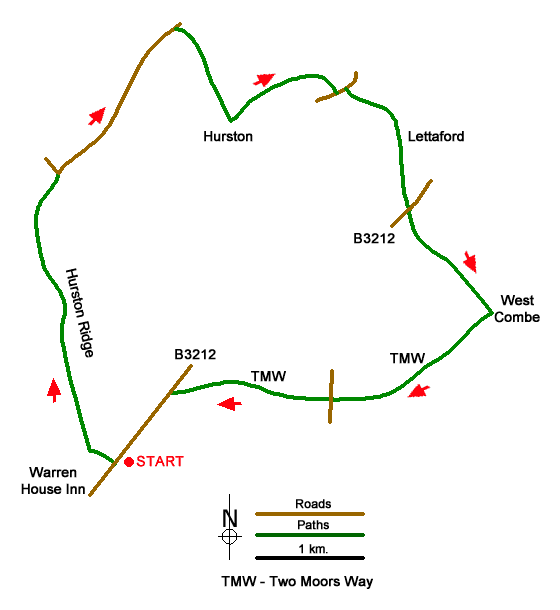
This varied Dartmoor circular walk starts from near the Warren House Inn. The route passes Hurston prehistoric stone row before exploring an area of beautiful Devon countryside to Hurston and on to Lettaford and West Coombe. From here the walk follows the Two Moors Way back to Bennett's Cross and the start. The walk includes some excellent views.
The walk starts from the small parking area (grid ref. SX676811) on the east side of the B3212 200 metres north of the Warren House Inn. After parking cross walk a few metres back towards the Inn and cross to a small tree adjacent to the road. Pass the tree on your right and walk ahead up to a wall. Turn left along the wall (wall on your right) and continue to a wall corner (grid ref. SX673812). Turn right and keeping the wall on your right follow the path in a northerly direction. After 200 metres the path trends away from the wall across Hurston Ridge.
Reaching a path junction (grid ref. SX671823), bear right. A short distance beyond this junction a short detour to the right will take you to the Hurston stone Row, one of the finest on Dartmoor. Return to the path and continue north. The path trends towards the edge of Fernworthy Forest on your left and eventually leads to a road (grid ref. SX670837). Turn right and follow the road for just under two kilometres. As the road descends turn right up steps opposite the entrance to Yardworthy Farm (grid ref. SX681850).
The path follows the right-hand field edge to reach a track. Turn right and after 150 metres turn left at Lower Shapley. Continue on the signed path through fields to reach Hurston. Turn left onto a lane and after 250 metres turn right (signed Mariner's Way, Jurston). Note OS 1:25k map incorrectly shows this path as the Two Moors Way. Continue over two bridges and the go left over a stile. Turn left to Lingcombe and then right onto a path which follows the left-hand field boundary to reach Jurston (grid ref. SX670844). Turn left along the lane and after 50 metres turn right to follow a track through to Lettaford.
Turn right (signed 'path') and after 20 metres head left to continue along the Mariner's Way over fields to reach Leapra Cross and the B3212 (grid ref. SX702833). Cross the road, pass through a gate and follow the driveway to pass Moor Gate. Continue across fields down a valley to West Coombe (grid ref. SX710825). Turn right past the farmhouse and head up a bridleway to King's Barrow. When concrete ends, keep ahead as signed keeping a stream on your left. Pass a pond and old mine workings also on your left. Continue up to gate, first seen on the skyline (grid ref. SX699817).
Pass through the gate and walk west to join the Two Moors Way. Continue down to lane. Maintain direction on the other side of the lane staying on the Two Moors Way. The path crosses the northern flank of end of Birch Tor to descend to the B3212 at Bennett's Cross. Turn left along the B3212 following a path parallel to the road. The start is about 800 metres along this path.
Messaging & Social Media
Message Walking Britain and follow the latest news.

Mountain Weather
Stay safe on the mountains with detailed weather forecasts - for iOS devices or for Android devices.