Walk 1780 - printer friendly version
Warren Wood and Little Marlow Walk
Author - Lou Johnson
Length - 4.4 miles / 7.2 km
Ascent - 300 feet / 91 metres
Grade - easy
Start - OS grid reference SU884875
Lat 51.5794400 + Long -0.7256480
Postcode SL8 5PT (approx. location only)
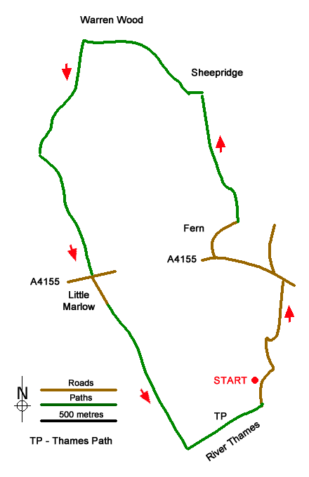
A circular walk exploring the area east of Little Marlow. The route includes pleasant woodland, and a section along the River Thames using the Thames Path. The walk starts from the small free Spade Oak car park (grid ref. SU884875) on the west side of Coldmoorholme Lane south of the A4155 at Well End.
After parking walk north back to the A4155 passing the Spade Oak Hotel (Bourne End) on your right. Reaching the A4155, turn left along the pavement. Continue past the roundabout and after 400 metres turn right into Fern Lane. Continue through Fern to the end of the lane (grid ref. SU882886). Keep straight ahead ignoring the bridleway on the right. Pass a house and continue uphill to reach the corner of Bloom Wood. Turn left along the edge of the wood and after 80 metres turn right through a gate. Almost immediately fork left (arrow on tree) and continue ahead ignoring cross tracks.
Reaching a marker post (grid ref. SU876897), turn left along the Chiltern Way through Warren Wood. After 400 metres you reach a junction of paths (grid ref. SU872897) where you turn left downhill. You soon leave the Bloom Wood following a stony track which is followed to the A4155 at Little Marlow. Cross the A4155 with care to Church Road opposite. Pass St John's church on your right and continue ahead to follow a track (The Moor) which leads under a railway to reach the River Thames.
Turn left along the Thames Path. After 600 metres turn left through gates, cross the railway line, and continue along the lane back to the start.
Continue along the clear track for 800 metres to a junction (grid ref. NH148228). Turn right into Coire Leachavie and follow the clear track into the Corie. The track is clear and easy to follow and gains height steadily towards the head wall. The path zigzags for a short section before following a traverse across the slope to reach the bealach at the foot of Mam Sodhail's south ridge.
Messaging & Social Media
Message Walking Britain and follow the latest news.

Mountain Weather
Stay safe on the mountains with detailed weather forecasts - for iOS devices or for Android devices.