Walk 1792 - printer friendly version
Somersby and Tetford Circular Walk
Author - Lou Johnson
Length - 6.0 miles / 9.8 km
Ascent - 350 feet / 106 metres
Grade - easy/mod
Start - OS grid reference TF333748
Lat 53.2534750 + Long -0.0034025
Postcode LN9 6QH (approx. location only)
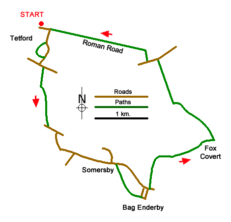
Circular walk in the rolling landscape of the Lincolnshire Wolds from Tetford passing through the villages of Somersby and Bad Enderby. The route is part of the Tennyson Trail which links a number of locations with the Poet Lord Tennyson. The start is North Road in Tetford where on-street parking is available near a school (grid ref. TF333748). After parking walk east and follow the road as it bends right into East Road passing the church on your left. Pass the White Hart inn, a favourite haunt of Tennyson. Where the road bends left, go through the kissing gate on the right. Follow the enclosed path through another gate and then bear left through a gate and follow the stream (on your left) to return to East Road. Turn right and continue to a T-junction.
Turn left along South Road. Take the first signed path on the right between houses. Continue along the right-hand side of a field to reach a path junction (grid ref. TF332739). Turn left on a path initially between hedges that leads down the right-hand side of a field to a road. Turn left onto Bridge Road and follow the road as it bends right and then left to reach a triangular junction where you continue ahead towards Somersby. Cross the River Lymm which was the inspiration for one of Tennyson's poems. Continue into Somersby passing the former rectory of Tennyson's father on the right.
Pass the church on your left where Tennyson's father is buried. Continue ahead and after 100 metres turn right onto a signed footpath. Walk through the yard of White House Farm to bear left over a stile. The path goes half right down the field. Maintain direction across the next field towards the far corner. Cross the stile and follow the left-hand field edge walking parallel to a wood on your left. The path continues between cottages and joins a track (grid ref. TF347721). Follow the track to reach a lane in Bag Enderby with the church opposite.
Turn left in front of the church and follow the lane to reach a T-junction. Turn right and then almost immediately left onto a track with adjacent footpath fingerpost. Stay on the track north and follow it as it bends right. A kilometre beyond this bend you reach a junction (grid ref. TF361730). Turn left and initially follow the right-hand side of a field. The track crosses a stream and continues along the left-hand side of a field with trees to your left. The route turns left to briefly pass through trees before turning sharp right with trees on your right. Maintain direction keeping the field boundary on your left with Warden Hill also on your left to reach a lane (grid ref. TF352743).
Turn left along Harden's Lane and after 150 metres take the signed footpath on the right. Cross the small wooden bridge and keep to the filed edge to reach a footpath sign. The path then makes a beeline across fields towards the rear of the church in Tetford. Pass through the gate into the churchyard and continue to the main entrance and a road from where you return to the start.
Messaging & Social Media
Message Walking Britain and follow the latest news.

Mountain Weather
Stay safe on the mountains with detailed weather forecasts - for iOS devices or for Android devices.