Walk 1960 - printer friendly version
Worms Head from Pilton Green Walk
Author - Lou Johnson
Length - 7.5 miles / 12.2 km
Ascent - 900 feet / 273 metres
Grade - easy/mod
Start - OS grid reference SS446871
Lat 51.5613110 + Long -4.2432495
Postcode SA3 1PE (approx. location only)
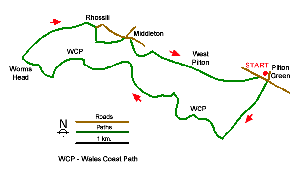
This walk in the Gower Peninsula from Pilton Green explores a beautiful section of coast to reach Worms Head. The route continues along the Wales Coast Path to Rhossili where paths return across pleasant countryside back to the start. The walk uses good paths, and the coastal section of the route offers excellent views.
The start is Pilton Green on the B4247 east of Rhossili where parking is available on the grass verge beside the road leading to Pilton Green Farm (grid ref. SS446871). After parking walk to the main road and take the footpath opposite. The well-trodden path leads across fields keeping the right-hand hedge. After just over a kilometre of easy walking you reach the Wales Coast Path (grid ref. SS439861) at Foxhole Slade.
Turn right along the coast path. After 100 metres you can turn left towards the sea above Horse Cliff for a fine view. Return to the main path, turn left initially following a wall on your right. The path skirts the head of rocky valley to reach the site of a fort. The path turns inland to avoid another valley before regaining the cliff tops (grid ref. SS427868). After another 500 metres you have the option of veering left of the Wales Coast Path at Thurba Head with another fort and a fine view across Mewslade Bay. Return to the main path and descend steeply into a valley.
Leave the valley on the clifftop coast path with the beach below on your left and continue to Tears Point. Continue on the coast path as it bends sharp right heading the coastguard hut from where you get a fine view to rocky Worms Head. An option (subject to tides) is to descend steps down to the causeway which links the mainland with Worms Head. A path leads all the way over Inner Head to Worms Head. Allow about 45 minutes for this option.
From the coastguard hut continue along the Wales Path heading north-east towards Rhossili. Pass the carpark and join the B4247. Follow the road until it bends left and take the track on the right alongside a garage on the left (grid ref. SS416880). Keep ahead for 250 metres to a T-junction and turn left. Follow the enclosed path to return to the B4247 in Middleton. Turn right along the B4247 and after 200 metres, turn right between buildings (broken fingerpost). Follow the path down to Mew Slade (grid ref. SS424875).
Fork left onto a track between trees and follow the path to exit onto a lane at Pitton (grid ref. SS427876). Turn right along the lane and after 200 metres take the first path on the left (grid ref. SS428875). Walk half right across the first field and then left following the field boundary on your left. Continue south-east to West Pilton. The path bends left and after the second path turn right and follow path keeping East Pilton farm on your left. Just past another pond, turn left into a field. Once in the filed follow the path with a hedge on your immediate right and continue back to Pilton Green.

Mountain Weather
Stay safe on the mountains with detailed weather forecasts - for iOS devices or for Android devices.

