Walk 1990 - printer friendly version
Settrington from North Grimston Walk
Author - Lou Johnson
Length - 7.3 miles / 11.9 km
Ascent - 700 feet / 212 metres
Grade - easy/mod
Start - OS grid reference SE843678
Lat 54.0991990 + Long -0.7123814
Postcode YO17 8AX (approx. location only)
A circular walk from North Grimston in the Yorkshire Wolds. The route explores the countryside to the north of the village and includes upland and valley walking. The walk passes through Settrington with its imposing House and parkland, and a small lake. The onward route climbs onto the Wolds and Settrington Beacon before descending gently back to the start. During the walk sections of the Yorkshire Wolds Way and Centenary Way are followed.
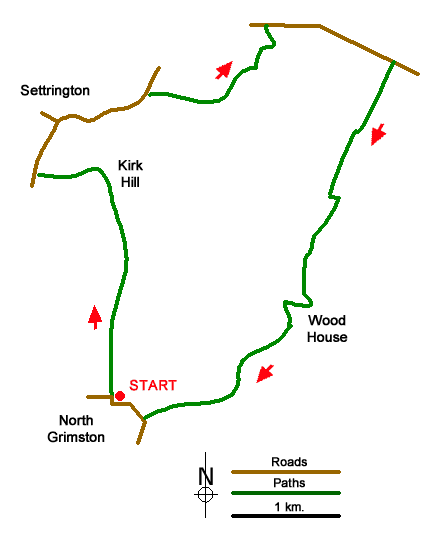
The walk starts from North Grimston where a small carpark on the east side of the Parish Church (grid ref. SE843678). An alternative (for patrons) is to park at the nearby Middleton Arms. After parking, follow the track heading north from the B1248 on the east side of the church. You are now following a section of the Centenary Way. The route crosses fields to reach Bellmanear Farm where the path skirts to the left of the property. Heading north the path crosses fields with a hedge on your left. Just before Kirk Hill you join a track. Which is followed around to the left. The track leads to Back Lane (grid ref. SE836696).
Turn right and continue ahead at the first junction (signed Settrington). At the next junction turn right (signed Settrington House). Continue along the lane soon passing the House on your left and a lake on your right. 800 metres from the road junction you reach a track on the right with a wooden fence opposite (grid ref. SE846703). Follow the track which leads to Wardale Farm. Where the track bends left leave the track and follow the path through a gap in trees. Once through the gap veer left and follow the path with the wood on your left. Continue along the waymarked path past a pond and then climb steeply aiming to the left of Wold House before joining the access drive to a road (grid ref. SE855709).
Turn right along the road and continue to Settrington Beacon, which is the highest point of the walk. At the end of the trees on your right, turn right onto a track (Yorkshire Wolds Way and Centenary Way). After a kilometre, the path turns left (grid ref. SE861695) and shortly after right to run beside a wood on your right. Continue along the clear track past Wood House Farm and back to the B1248 at North Grimston. Turn right and return to the start.
Messaging & Social Media
Message Walking Britain and follow the latest news.

Mountain Weather
Stay safe on the mountains with detailed weather forecasts - for iOS devices or for Android devices.