Walk 1991 - printer friendly version
Vat of Kirkbuster & Bay of Houseby Walk
Author - Lou Johnson
Length - 7.6 miles / 12.4 km
Ascent - 400 feet / 121 metres
Grade - easy/mod
Start - OS grid reference HY682241
Lat 59.1025860 + Long -2.5568847
Postcode KW17 2AG (approx. location only)
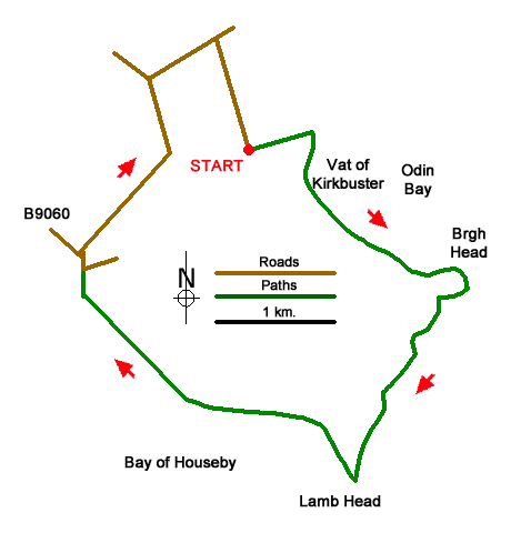
The island of Stronsay lies in the eastern sector of the Orkney Islands. This walk explores the east coast of Stronsay, and the highlights include the Vat of Kirkbuster, a rugged coastline, the Bay of Houseby and, in season, abundant birdlife. The route follows the coastal path and uses quiet lanes for the inland section of the walk.
The start is the small parking area for the Vat of Kirkbuster (grid ref. HY682241). After parking pass through the gate and follow the enclosed path east to the coast. Turn right and follow the grassy path along the cliff tops to reach the Vat of Kirkbuster a blowhole cut into the cliffs. Continue along the coast path to reach Burgh Head where the path veers south for a two-kilometre section to Lamb Head.
Continue along the coast path (indistinct in places) for a further 1.5 kilometres around the Bay of Houseby. Reaching the Pow, a rocky area of foreshore, turn right up a concrete track (grid ref. HY676221). After just under a kilometre the track leads into a tarmac lane. Continue ahead to reach a junction with the B9060 at the South Schoolhouse. Again, continue ahead soon reaching a bungalow where the lane bends left. Continue along the lane for 600 metres to the next junction (grid ref. HY674276). Turn right (brown sign to Vat of Kirkbuster). At the next junction turn right and continue along the lane to the parking area.
Messaging & Social Media
Message Walking Britain and follow the latest news.

Mountain Weather
Stay safe on the mountains with detailed weather forecasts - for iOS devices or for Android devices.