Cat Bells from Gutherscale
Lake District Walk
Nat Park - Lake District - Lake District North Western Fells
Wainwrights - Catbells
County/Area - Cumbria
Author - John Paterson
Length - 4.0 miles / 6.5 km Ascent - 1200 feet / 364 metres
Time - 3 hours 10 minutes Grade - easy/mod
Maps 

| Ordnance Survey Explorer OL4 | Sheet Map | 1:25k | BUY |
| Anquet OS Explorer OL4 | Digital Map | 1:25k | BUY |
| Ordnance Survey Landranger 90 | Sheet Map | 1:50k | BUY |
| Anquet OS Landranger 90 | Digital Map | 1:50k | BUY |
Walk Route Description
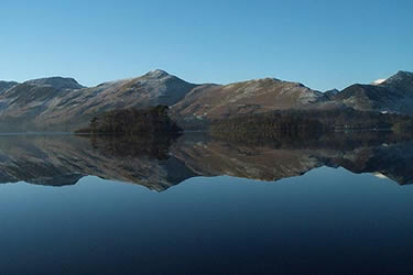
Click image to visit gallery of 6 images.
Catbells is a justly popular fell, beautifully situated between Derwentwater and Newlands. It is often climbed as the first peak in the circuit of fells at the head of the Newlands valley but it is a very worthwhile short Lake District walk with delightful views encompassing most of the fells of the northern Lakeland. Note: This description assumes that the foot of the fell is reached by car but an excellent alternative (which will appeal to children) is to catch a pleasure boat from the landings at Keswick and disembark at Hawse End which is less than 400 yards from the carpark at the foot of the north ridge. For the quickest trip to Hawse End catch a boat heading anticlockwise round the lake. On the return, choose a clockwise boat for a quick trip back or an anticlockwise boat for a cruise round Derwentwater. Boats run most days of the year apart from Christmas Day and timetables are available from the boat landings or the tourist office in the Moot Hall, Keswick.
Park at Gutherscale in the Newlands Valley (GR NY246211) at a small carpark between Hawse End and Skelgill.
From the carpark a sign points to a traverse path leading to the foot of the north ridge. The path up the north ridge is excellent and height is quickly gained giving ever improving views of Derwentwater, Swinside, Keswick, Borrowdale and the Newlands valley. The northern shoulder is reached by a short easy scramble on rock. Beyond the shoulder a level saddle provides easy walking leading to the final steep section below the summit rocks. The summit is an airy dome with excellent views in all directions including the tiny village of Little Town seen far below in the Newlands valley. Stair was the home of Mrs Tiggywinkle (the hedgehog) in the children's books by Beatrix Potter.
From the summit descend south to the col of Hause Gate. Beyond Hause Gate the ridge continues to Maiden Moor and the circuit of the Newlands valley but our route takes the path which descends the eastern side of the ridge below Hause Gate by a series of zig zags with fences guarding the steeper sections. Avoid all "shortcuts" heading north and stay on a southerly line down the fellside until the road is reached. At the road turn left (north), pass the Low Manesty caravan park entrance and after 200 yards pass through a gate on the right into Low Manesty woods - a good place to see red squirrels. The track through the woods is tarmac until Derwentwater is reached when it becomes a delightful woodland track sticking fairly closely to the shore. After nearly 2 miles Hawse End activity centre is reached. (A Jetty here allows those who came by boat from Keswick to embark for their return journey). Walkers who arrived by car should exit the grounds of Hawse End and turn left up the hill where a footpath soon leads to the road and a further 200 yards walking leads to the carpark at Gutherscale.
Other walks nearby
| Walk 1155 | Causey Pike | moderate | 6.3 miles |
| Walk 1187 | Robinson & Hindscarth | mod/hard | 6.5 miles |
| Walk 1356 | Walla Crag | easy/mod | 4.5 miles |
| Walk 3029 | Derwentwater & Walla Crag | easy/mod | 6.5 miles |
| Walk 3037 | High Seat & Bleaberry Fell from Keswick | moderate | 9.0 miles |
| Walk 2321 | Shores of Derwentwater from Keswick | easy | 3.5 miles |
| Walk 1108 | Ashness Bridge & Grange Fell | moderate | 9.0 miles |
| Walk 1120 | Grisedale Pike & Crag Hill fro Braithwaite | mod/hard | 8.5 miles |
| Walk 2038 | Tower Ridge on Eel Crag returning via Sail & Barrow | hard | 6.3 miles |
| Walk 1268 | Cat Bells & High Spy | moderate | 8.0 miles |
Recommended Books & eBooks
Walking the Lake District Fells - Mardale and the Far East
 Part of the Walking the Lake District Fells series, this guidebook covers a wide range of routes to 36 Lakeland summits that can be climbed from the Ullswater, Haweswater, Troutbeck, Kentmere and Longsleddale valleys, with highlights including High Street, Place Fell and the Kentmere fells. Suggestions for longer ridge routes are also included.
More information
Lake District: High Level and Fell Walks
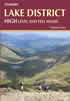 This guidebook describes 30 graded fell walks on the ridges and high peaks of the English Lake District, the UK's most popular national park. Reaching some of England's finest and highest mountain scenery, this guide leads readers to classic horseshoes and traditional ascents as well as lesser-known routes to quieter summits.
More information
Messaging & Social Media
Message Walking Britain and follow the latest news.

Mountain Weather
Stay safe on the mountains with detailed weather forecasts - for iOS devices or for Android devices.