Walk 2180 - printer friendly version
Hamstead Park from Kintbury Walk
Author - Lou Johnson
Length - 7.3 miles / 11.9 km
Ascent - 450 feet / 136 metres
Grade - easy/mod
Start - OS grid reference SU386672
Lat 51.4025230 + Long -1.4464920
Postcode RG17 9UN (approx. location only)
Berkshire walk from Kintbury exploring a section of the Kennet and Avon Canal and Hamstead Park. The Kennet and Avon Canal links London with the Bristol Channel with a length of 87 miles. Hampstead Park has a long history and today the motte and bailey castles, the fishponds and nine surviving portions of the 13th century park pale can be seen today. The grand mansion was destroyed by fire in 1718 and the adjoining formal gardens slowly disappeared.
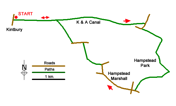
The walk starts from Kintbury railway station (grid ref. SU386672) where parking is available in the station car park and across the road by Kintbury Lock. After parking walk south towards the village centre and turn left onto the canal towpath (before crossing the canal). Continue along the towpath for four kilometres to reach Hamstead Lock and bridge (grid ref. SU424671). Landmarks along the canal include Shepherd's Bridge, Dreweat's Lock and Copse Lock.
At Hamstead Lock follow the towpath up to the road and turn right. After 120 metres turn left through the kissing gate into Hamstead Park and join a clear track, ignoring the first footpath on the right. Continue along the track soon passing a large pond on the right. The track then climbs through the parkland. Approaching a white bungalow on the left of the track, veer left off the track to cross a small footbridge (grids ref. SU428661). Keep ahead on the grassy path soon joining a tarmac drive. Bear left along the drive and continue to the point where it bends left (grid ref. SU431657).
The route turns right here, by a fingerpost, along a grassy path. (If you have time there is a monument to US paratroopers a few metres further along the drive.) The path descends and runs besides trees on your right. The path briefly passes through trees before veering left to run alongside a former plantation to reach a road. Turn right along the road and go straight across the first junction. Stay on the road through Hamstead Marshall and continue to the next junction (grid ref. SU412656). Fork right (signed to Marsh Benham) and continue for 250 metres to where the road bends right and turn left over a stile onto a signed footpath (grid ref. SU411659).
The onward path crosses a field aiming for the right-hand corner of a small wood. Cross a track and maintain direction to the next track. Turn right and keep ahead for 500 metres between fences to reach a lane (grid ref. SU406666). Turn left along the lane, cross a stream and continue up to the next junction. Just past the junction, turn right through a hedge onto the signed footpath. The path goes half-left across a large field to enter woodland. Reaching a grassy track, bear right and continue out of the trees. The path then makes a beeline down to Shepherd's Bridge. Cross the bridge and turn left to re-join the towpath to return to the start in Kintbury.
Messaging & Social Media
Message Walking Britain and follow the latest news.

Mountain Weather
Stay safe on the mountains with detailed weather forecasts - for iOS devices or for Android devices.