Walk 2190 - printer friendly version
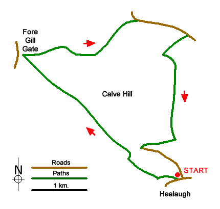
Calver Hill & Reeth Low Moor Walk
Author - Lou Johnson
Length - 6.0 miles / 9.8 km
Ascent - 1000 feet / 303 metres
Grade - easy/mod
Start - OS grid reference SE017990
Lat 54.3864850 + Long -1.9753292
Postcode DL11 6UB (approx. location only)
Walk from Healaugh in Swaledale explores the moors to the north of the village. The route begins by following Barney Beck upstream before climbing out of the valley and onto the moors. Skirting the western slopes of Calver Hill, the walk continues across Cringley Hill to reach Fore Gill gate. From where the route turns east to road above Arkle Town in Arkengarthdale. After a brief section of road walking the walk crosses Reeth Low Moor across the eastern side of Calver Hill to return to Healaugh.
The start is the centre of Healaugh village (SE017990) where limited parking is available by the notice board beside the B6270. Alternative parking is described in the final paragraph. After parking walk west along the B6270 and turn right before the phone box. Follow the lane and take the first signed footpath on the right. The path leads across fields to join a bridleway (grid ref. SE014990). Turn right along the bridleway. The route soon reaches an isolated house on the right. Continue ahead into trees.
Leaving the trees follow the path with a wall on your left. Continue uphill to pass Nova Scotia (grid ref. SE008996). The onward grassy track soon runs alongside a large walled enclosure on your right. At the end of the enclosure, bear right, cross a track, and maintain direction up to a second walled enclosure. Once past this enclosure, maintain direction across the moor. The path is generally clear on the ground and head roughly northwest to reach the road at Fore Gill Gate (grid ref. NY993009).
Just before the road, turn sharp right along a clear track heading east. Follow the track for about two kilometres across the moor. At grid ref. NZ008013 fork right on to a narrower path which leads to a road. If you miss this path stay on the track which also leads to the road. Turn right along the unfenced road and continue for 700 metres a farm track on the left (grid ref. NZ018012).
The small layby is alternative starting point. To continue turn right on the signed footpath which climbs gently across the moor to reach a path junction (grid ref. NZ015009). Turn left on a path that contours across the hillside. The grassy path bends gently right before turning south across the eastern slopes of Calver Hill. The path climbs gradually reaching an isolated section of wall on your right (grid ref. NZ016000). From here the path descends gently in a southerly direction. Continue to reach a clear track and turn right (grid ref. SE107996). Reaching Thirns, bear left and join a tarmac lane which descends into Healaugh.
Messaging & Social Media
Message Walking Britain and follow the latest news.

Mountain Weather
Stay safe on the mountains with detailed weather forecasts - for iOS devices or for Android devices.