Walk 2275 - printer friendly version
Lowbury Hill & The Fair Mile Walk
Author - Lou Johnson
Length - 7.8 miles / 12.7 km
Ascent - 750 feet / 227 metres
Grade - easy/mod
Start - OS grid reference SU556796
Lat 51.5125990 + Long -1.2001836
Postcode RG8 9SE (approx. location only)
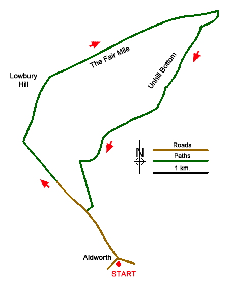
Walk from Aldworth exploring the Berkshire Downs. The route uses paths, tracks, and lanes to explore the rolling countryside and woodland including Lowbury Hill, the site of a Roman Temple, The Fair Mile, and Unhill Woods.
The start is the village of Aldworth where limited on road parking is available (grid ref. SU556796). Patrons can also use the Bell Inn car park although please ask before parking. After parking and with your back to the New Inn, turn right along Ambury Road. Keep right at the next junction and with a row of cream houses on the left continue ahead for 1.5 kilometres to reach a solitary house on the left (Starveal). Continue ahead to a junction of tracks with a three-way fingerpost (grid ref. SU540815). Cross the Ridgeway and take the track opposite.
Continue ahead on the rising track (with hedge left) across the flank of Lowbury Hill. Continue over the brow of the hill and after 400 metres turn right along the Fair Mile. Continue for three kilometres descending the track down the centre of a broad grassy strip. On the way you pass the entrance to Ashdown Motorcross Track on your left after which you pass through an area with small trees and shrubs. The view to the right opens up and the next objective is a marker post on the right. Turn right here, cross the stile, and follow the hedge downhill. Where the hedge bends to the left, continue ahead down to a track.
Turn right along the track, pass Starveal Farm, and continue to a T-junction of tracks (grid ref. SU5708340. Turn left and follow the rising track. You pass through trees and then an open field of your right. Where the track bends right (grid ref. SU563823) continue ahead into Unhill Woods on a path indicated by a fingerpost. Shortly after fork left and continue uphill. Continue along the path through trees to a Pheasant feeding station and turn right. Continue along the path to reach a tarmac lane. Turn right and continue to reach a junction after 800 metres (grid ref. SU555817). Continue ahead (waymarks) through trees following the path to a stile. Cross the stile and turn right along an access track. Pass through a gate and continue to the Ridgeway (grid ref. SU552812). Turn right and after 200 metres turn left along a clear track. Follow this track to reach a T-junction and turn left along Ambury Road back to the start in Aldworth.
Messaging & Social Media
Message Walking Britain and follow the latest news.

Mountain Weather
Stay safe on the mountains with detailed weather forecasts - for iOS devices or for Android devices.