Walk 2293 - printer friendly version
Weets Hill Walk
Author - Lou Johnson
Length - 5.3 miles / 8.6 km
Ascent - 800 feet / 242 metres
Grade - easy/mod
Start - OS grid reference SD880459
Lat 53.9091140 + Long -2.1841505
Postcode BB18 5BY (approx. location only)
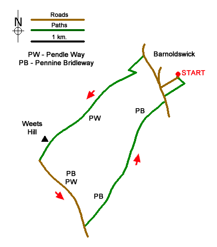
Starting from Barnoldswick this walk's main objective is Weets Hill (397 m.) which offers an excellent view of Pendle Hill in the Forest of Bowland and to the north to the Yorkshire Dales National Park. The route follows sections of the Pendle Way and Pennine Bridleway including a short section along a quiet lane.
The start is the free car park at Letcliff Hill Country Park (grid ref. SD880459). After parking return along the access road to the B6251 and turn right. Continue along the road for 150 metres and fork left into Gillian's Lane. Then turn left along Moorgate Road, which soon becomes Folly Lane. You are now following the Pendle Way with distinctive waymarks featuring a witch and broomstick. The track climbs steadily, soon bending left and then right. 500 metres beyond this bend turn right through a gate (grid ref. SD868457) just past buildings on your left. The clear path crosses pastures running parallel to a wall on your left. A steady climb leads onto open moorland with the path continuing beside the wall. After 300 metres veer right off the main path to reach the OS trig column on Weets Hill. Allow time to enjoy the extensive view.
To continue, bear left to the path beside the wall and continue downhill to the Gisburn Old Road and turn left. You are now also following the Pennine Bridleway. Continue past Weets House Farm (on your right) and after just under a kilometre pass Star Hall (on your left). Shortly after the Pendle Way turns right off the lane. Continue ahead and ignore the first signed path on the left. Continue for another 120 metres and turn left along Lister Well Road (a track) continuing with the Pennine Bridleway. You now have an easy downhill walk of under three kilometres to reach the B6251. Turn left and almost immediately right into Hodge Lane. Follow the lane/track for 450 metres to where it bends left. Leave the lane here and turn left along a signed footpath which leads back to the car park.
Messaging & Social Media
Message Walking Britain and follow the latest news.

Mountain Weather
Stay safe on the mountains with detailed weather forecasts - for iOS devices or for Android devices.