Walk 2381 - printer friendly version
St Margaret's at Cliffe from Kingsdown Walk
Author - Lou Johnson
Length - 6.3 miles / 10.2 km
Ascent - 850 feet / 258 metres
Grade - easy/mod
Start - OS grid reference TR380485
Lat 51.1861450 + Long 1.4043740
Postcode CT14 8AG (approx. location only)
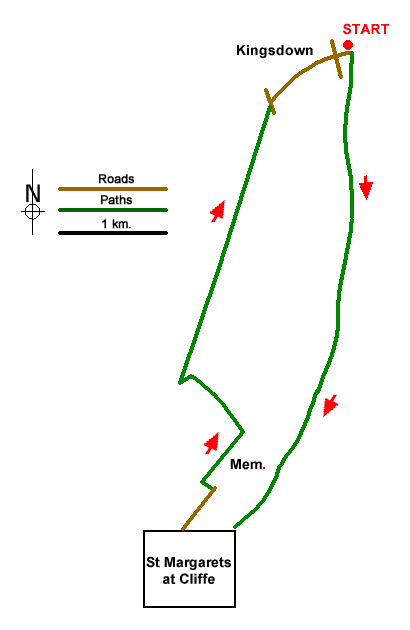
Starting from Kingsdown this circular walk follows the coastal path south to St Margaret's at Cliffe before returning by an inland path back to the start. The coastal path runs along the top of white chalk cliffs and offers views across the English Channel to the French Coast. The inland stretch of the route crosses farmland with limited views to the sea.
The walk starts from where limited parking is available on Kingsdown seafront along the southern end of Wellington Parade (grid ref. TR380485). After parking join the signed coastal path and head south with sea to your left. After a short section of concrete path, the route runs along the back of the beach before veering right to join a road. Continue south along the road to a right-hand bend. Leave the road and climb the steps on the right to reach the cliff top path. Follow the coastal path for 2.5 kilometres to reach the Dover Patrol Memorial (grid ref. TR374452).
With tour back to the memorial, pass through the wooden kissing gate ahead and bear right to rejoin the coastal path with views ahead to the white cliffs. Keep to the path nearest the sea to reach a series of steps which lead down to the seafront in St Margaret's at Cliffe. Turn right and just before the Coastguard Pub, bear right up Bay Hill. Arriving at the first junction take the signed footpath opposite. Climb the steps and continue up to re-join Bay Hill. Turn right and at the next junction fork left into Hotel Road. After 100 metres turn left up steps onto a signed footpath. Reaching Granville Road go straight across along Cavanagh Road. At the end, join a grass path that leads up to The Droveway (grid ref. TR366448).
Turn right and continue for 500 metres into open countryside. The lane bends left and then right to pass Bockhill Farm on your right. Just past the farm buildings the track bends left ad continues across fields. After 600 metres the path bends left through a kissing gate to join a clear track. Turn sharp right to follow cycleway no.1. The track passes between trees where you turn left through the hedge into a field. Continue along the clear path for about 1400 metres to reach Victoria Road (grid ref. TR373478). Bear right and follow the road to a junction., Turn left along The Avenue and the right down Upper Street. Follow this road keeping ahead at all junctions to reach Cliffe Road. Go straight across down a narrow road (South Road) and continue the short distance back to the start on Kingsdown seafront.
Messaging & Social Media
Message Walking Britain and follow the latest news.

Mountain Weather
Stay safe on the mountains with detailed weather forecasts - for iOS devices or for Android devices.