Walk 2396 - printer friendly version
Finmere & Westbury Walk
Author - Lou Johnson
Length - 6.1 miles / 9.9 km
Ascent - 320 feet / 97 metres
Grade - easy/mod
Start - OS grid reference SP609340
Lat 52.0011090 + Long -1.1143047
Postcode NN13 5RG (approx. location only)
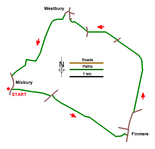
A relaxing walk from Mixbury exploring the countryside northwest of the village. The route uses paths and bridleways and visits the villages of Finmere and Westbury (Bucks). Part of the walk passes through the valley of the River Great Ouse. The walk starts from Evenlley Road in Mixbury where on-street parking is available near All Sanits Church (grid ref. SP609340).
After parking, enter the churchyard and follow the path keeping the church on your left and continue to Church Lane. Turn right and follow the lane for 800 metres to a T-junction. Turn left and almost immediately right onto a signed footpath. Path runs parallel to the railway before veering half-left soon passing through a small wood. Continue ahead across two stiles to join a path between a hedge and stables near Warren Farm.
Follow the onward path initially with a hedge on the left. To reach a stile on the left. Cross this and turn right to follow path with a hedge on the right. Continue through Hill Leys Farm and join their access drive. Continue to a T-junction and cross the stile opposite. Pass a small pond to a gate. Continue across next field to a stile. Once across the stile veer half-left to the left-hand corner of the field. Follow a narrow path which exits onto a residential road. Turn right and continue down to a T-junction (grid ref. SP636329). Turn left and walk through Finmere village. Where thro ad forks, keep right and continue past the parish church on your right. 450 metres beyond the church the road bends right.
Continue ahead, as indicated by the adjacent finger post, along an avenue of trees. Cross the old railway trach and continue on a clear path to reach a footbridge over the River Great Ouse. Once across the river, the path trends slightly left and then continues across fields to a road. Cross the road to a gate opposite and follow a grassy track with a hedge on your right. The track leads to Fields Barn Farm. Keep ahead through the farmyard and follow a tarmac drive to a road (grid ref. SP626353). Briefly turn right and then go left over a stile. Maintain direction across fields to enter St Augustine's churchyard in Westbury. Exit the churchyard onto a road and turn left.
Reaching a road junction, turn left and almost immediately left again at a Give Way sign. Follow Mill Lane past housing to reach the old mill. Take the tarmac drive to the right of the mill and continue to a gate giving access to a field. In the filed veer half-left the path south to cross the River Great Ouse (grid ref. SP617352). Once across the river, go straight across the old railway and main direction along a clear track. After 500 metres the track bends right to cross another old railway. After crossing the railway, continue following the track to exit at a lane. As an alternative you can take the path on the left which crosses fields to exit at the lane. Turn left and return to the start in MIxbury.
Messaging & Social Media
Message Walking Britain and follow the latest news.

Mountain Weather
Stay safe on the mountains with detailed weather forecasts - for iOS devices or for Android devices.