Ripon Rowel Walk Leg 3 - Sawley to Ilton
Nidderdale AONB Walk
Region - Nidderdale AONB
County/Area - North Yorkshire - Nidderdale AONB
Author - Phil Catterall
Length - 11.0 miles / 17.9 km Ascent - 1450 feet / 439 metres
Time - 7 hours 0 minutes Grade - moderate
Maps 

| Ordnance Survey Explorer 298 | Sheet Map | 1:25k | BUY |
| Anquet OS Explorer 298 | Digital Map | 1:25k | BUY |
| Ordnance Survey Landranger 99 | Sheet Map | 1:50k | BUY |
| Anquet OS Landranger 99 | Digital Map | 1:50k | BUY |
Walk Route Description
Click image to visit gallery of 10 images.
This walk description continues with the third leg of the 50 mile Ripon Rowel Walk. It is a varied linear walk and includes a truly beautiful section of the Nidderdale AONB. Public transport is not available. I suggest two cars be used or taxi (approx £ 18 at 2008 prices) to return from Ilton back to Sawley. A suggested parking spot near dwellings in Ilton is at either at grid ref. SE191781 (room for 2 cars) or at the grass triangle grid ref SE189783 (more space here). The route follows part of the 6.5 mile Crackpot Trail near Dallowgill and features grouse moorland, woodland walks, field paths, many tracks, green lanes, numerous footbridges and two lakes. The Ripon Rowel is extremely well waymarked, thanks to a lottery grant given some years ago and presents little difficulty with navigation. It is also shown in its entirety as a Long Distance Route on OS Explorer Maps 298/299.
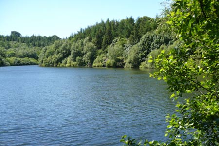
Starting from near Sawley Village Hall (grid ref. SE248677) where plentiful parking on grass is available. Look left well before the village hall to take a stile into the field. Follow the fence line west for 600m until a footpath/track crossroads is reached. Turn right here. At the field corner take the footpath left towards the B6265 where you turn left, then immediate right on a track to Gowbusk. Pass through the farm buildings and head west to keep to the right of the buildings at Hollin Hill Farm. Soon the woodland is reached as you drop down to cross an ancient packhorse bridge to reach Eavestone Lake. The picturesque lake is surrounded by millstone grit rock formations and rhododendrons.
You leave the lake and rejoin a lane passing through the hamlet of Eavestone. The lane turns into a track as you drop downhill to a wood curving around Brim Bray Pond. At the footpath junction (grid ref. SE214688) turn right to drop downhill to another of the many watercourses on this walk. The map here depicts a ford - not the case. As you reach the bottom corner of the field keep to the right and take the stile. You will soon find the footbridge crossing the River Skell. From here the Rowel is "not as map". The route shown on the map is via a track now planted with new woodland. You are waymarked to go via the footpath 200m to the west of the wood at its furthest point. A steep climb up the field takes you to a gate and onto a track to join a further concreted track to pass west of Skelding Grange.
Join the public road again at Drift Lane but continue on the rough track section of it north at grid ref. SE215701. The public road swings left here. Heading north this looks boring on the map but isn't in reality with its mix of tracks, field paths and moorland with an abundance of Curlew and Oyster Catcher evident. Holborn Beck is crossed (very muddy at the gate in the bottom even in dry weather) - could this be why the track is called Wetshod Lane? Towards the end of the lane look out for the first mosaics of the Crackpot Trail. We were supposed to pass ten out of a total of twenty two, but we only noticed six!
By now a thirst will have developed and at the junction with the public road (grid ref. SE211720) you will find The Drovers Inn. Open lunchtimes but only at weekends. Turn right at the junction and then immediate left into Belford Lane. Continue downhill via the rough track to again cross a footbridge. This area is covered with rising springs and many resulting becks which explains why the River Laver is a formidable river by the time it reaches the River Skell at Ripon a mere seven miles away. Keep following the well waymarked track until you reach the public road at grid ref. SE204736. Bear left downhill and then right on the farm track after 150m. You see the Carlesmoor Sighting Tower. This is a distinctive feature.
Be careful to take the hairpin right at the farm grid ref. SE194735, although this is waymarked it is easily missed. There are dogs at this farm, chained when we passed, but still worth giving a wide berth due to their nature. Turn left at the end of muck heap to drop down to the Sighting Tower, built to help triangulate the line of a water pipeline from reservoirs higher up the moor down to Harrogate. The sighting tower is actually built over the top of the aqueduct.
Another valley now, Ellershaw Gill, which helps explain the 1450 feet of ascent on this walk as we drop into it and then climb out. This is Stock Beck Moor and visitors are encouraged but dogs must be strictly controlled and kept on the public right of way. You reach a footbridge at grid ref. SE194746 and a boggy area afterwards. Go straight uphill from the bridge to reach a stile. This cannot be seen immediately and the tendency is to go right, but go straight ahead off the footbridge to reach Brown Bank Road.
Another climb up to Wreaks Lane where you turn right, then left after 200m to head NNE on the lane for one mile. At grid ref. SE200771 bear left to Mouscar. The path leads onto a grouse moor so again close control of any dogs is strongly advised. Once the moor is reached be careful not to go left at grid ref. SE98774 but be sure to follow the line of the stone Grouse Butts slightly to your left. When the dry stone wall is reached keep left and you will locate another of the many wall stiles already crossed on this excellent walk. The top of the hill at Manor Farm, Ilton can now be seen. If you parked here proceed to your vehicle. There is still a payphone at grid ref. SE190783 should you require it as mobile coverage is patchy in this area (June 2008).
The fourth leg of this walk can be found here Walk 2406
Other walks nearby
| Walk 3528 | Fountains Abbey & Markenfield Hall | moderate | 8.7 miles |
| Walk 3726 | Brimham Rocks Circular | easy | 4.7 miles |
| Walk 2404 | Ripon Rowel Walk Leg 2 - South Stainley to Sawley | easy/mod | 8.5 miles |
| Walk 2403 | Ripon Rowel Walk Leg 1 - Ripon to South Stainley | easy/mod | 10.0 miles |
| Walk 3507 | Dacre Banks Circular | easy/mod | 6.5 miles |
| Walk 1358 | Ripley & Knox circular | easy | 5.5 miles |
| Walk 1078 | Hampsthwaite & Ripley Park | easy | 7.5 miles |
| Walk 2261 | Pateley Bridge & Nidderdale Way | easy/mod | 7.1 miles |
| Walk 2407 | Ripon Rowel Walk Leg 5 - Grewelthorpe to Ripon | moderate | 12.0 miles |
| Walk 2406 | Ripon Rowel Walk Leg 4 - Ilton to Grewelthorpe | moderate | 10.5 miles |
Recommended Books & eBooks
Trail and Fell Running in the Yorkshire Dales
 Guidebook to 40 of the best trail and fell runs in the Yorkshire Dales National Park. Ranging from 5 to 24 miles, the graded runs start from bases such as Ribblehead, Dent, Sedbergh, Malham and Grassington and take in the region's diverse delights, from castles and waterfalls to iconic mountains such as Whernside, Ingleborough and Pen Y Ghent.
More information
Messaging & Social Media
Message Walking Britain and follow the latest news.

Mountain Weather
Stay safe on the mountains with detailed weather forecasts - for iOS devices or for Android devices.