Walk 2483 - printer friendly version
Cradley Circular Walk
Author - Lou Johnson
Length - 6.0 miles / 9.8 km
Ascent - 800 feet / 242 metres
Grade - easy/mod
Start - OS grid reference SO736471
Lat 52.1215780 + Long -2.3870062
Postcode WR13 5LH (approx. location only)
The village of Cradley (Herefordshire) lies a short distance west of the Malvern Hills in an area of wooded limestone hills. This walk explores this beautiful landscape using lanes, footpaths, and bridleways. Cradley and Mathon, visited in the early stages of the walk, both have a number of half-timbered buildings typical of the area including the listed village hall at Cradley.
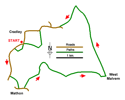
The walk starts from Rectory Lane, Cradley, where on-street parking is available near the church (grid ref. SO736471). After parking, walk back towards the war memorial, turn left, and continue along a lane. After 120 metres fork right and continue into a field and turn right again to a lane. Turn left along the lane and continue for 800 metres to reach a stile with fingerpost in the left-hand hedge. Cross the stile and veer half right to join a driveway. After 250 metres turn right to cross Cradley Book and continue along a path that runs to the left of Mathon Church to reach a road (grid ref. SO734458).
Turn left along the road. Just before a grassed island, turn left at a fingerpost to join the Wyche Way. The enclosed path soon re-crosses Cradley Brook and joins an enclosed track (ignore the footpath on the left). Follow this track soon reaching a cross track. Continue ahead along the track. When the track bends left continue ahead through a hedge to reach another track (grid ref. SO740462) keeping on the Wyche Way. Turn left and continue towards Netherley Hall across the flank of Cockshot Hill on your right. When the track forks, follow the waymarks for the Wyche Way. Do not follow the track but head across grass to reach a good path at the field edge.
Turn right on a rising path through woodland on Cockshot Hill. The path exits the trees and runs alongside woodland on your left soon veering left as a clear track to pass Bank Farm on your left. Beyond the farm the track bends sharp right. Continue ahead on the waymarked Wyche Way on a rising path towards Croft Farm (West Malvern). Just before the farm, cross a stile and turn left to leave the Wyche Way. The path soon enters woodland. Follow the main path north along the wooded ridge for two kilometres. On this section ignore all side paths and keep to the main path which follows the ridge.
After passing a section of open countryside on the left you reach a path junction (grid ref SO750482). Turn left here (the path ahead leads to a quarry) and descend quite steeply from Whitman's Hill. The path soon exits the trees and follows the follows the field edge to join a track. Ignore side paths and continue to a lane (grid ref. SO745476). Turn right along the lane. At first junction, turn left and continue for 400 metres to reach a house up on your left. Take the next path on the left which runs beside the bungalow before turning right beside farm buildings. The path enters Lumbridge Hill Wood and then exits via a stile on the right to enter fields. Bear right to cross a footbridge and continue on clear path across field to reach Cradley Village Hall. Continue ahead to return to the start.
Messaging & Social Media
Message Walking Britain and follow the latest news.

Mountain Weather
Stay safe on the mountains with detailed weather forecasts - for iOS devices or for Android devices.