Struie circular Walk
Walk 2504 - Route Maps & Profile
Route Map
Digital Maps - Copyright © 2011-2024. All rights reserved.
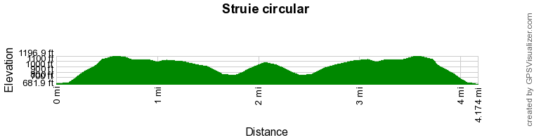
Route Profile
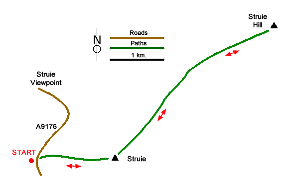
Sketch Map
Suggested Maps 

| Ordnance Survey Explorer 438 | Sheet Map | 1:25k | BUY |
| Anquet OS Explorer 438 | Digital Map | 1:25k | BUY |
| Ordnance Survey Landranger 21 | Sheet Map | 1:50k | BUY |
| Anquet OS Landranger 21 | Digital Map | 1:50k | BUY |
It is recommended you take a map. The preferred scale is 1:25k.
Start Point Details
Ordnance Survey Grid Ref NH650850
Latitude 57.834105 Longitude -4.275266
Postcode IV24 3DL
what3words start standing.equipping.empires
Walk description may contain detailed information on the start point for this walk.
Further Information
Highland
Highland is an administrative area which contains most of the Scottish Highlands. It is sparsely populated and contains some of the finest scenery in the British Isles. High Mountains, deep glens and lochs contain many great walks. The area includes Ben Nevis the highest mountain in the UK. The area also includes part of the Cairngorm National Park, an area of high mountains, and glorious Isle of Skye.
Walk grading - Learn how each walk is assessed and select a walk to suit your ability and experience by going to Walk Grading Details.
Messaging & Social Media
Message Walking Britain and follow the latest news.

Mountain Weather
Stay safe on the mountains with detailed weather forecasts - for iOS devices or for Android devices.