Walk 2507 - printer friendly version
South Head & Edale Cross from Hayfield Walk
Author - Mike Bexley
Length - 8.0 miles / 13 km
Ascent - 1520 feet / 461 metres
Grade - moderate
Start - OS grid reference SK036869
Lat 53.378941 + Long -1.9473477
Postcode SK22 2JD (approx. location only)
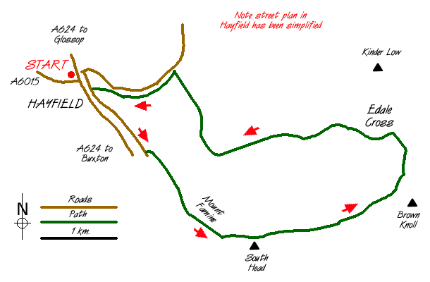
This Peak District walk visits the more remote areas to the east of Hayfield, includes good views and a safe crossing over the moors. The walk can be extended to include the Kinder Edges. The start is in the Hayfield Car Park (grid ref. SK036869) where a fee is payable. Leave the car park and take the steps which lead you under the by-pass. You will pass the Kinder Mountain Rescue Teams Hut on left. Go straight on to the road in front of The George Hotel.
Turn right on this road then first left only to bear to the right up Highgate Road, which is marked and named on the OS 1:25000 map. Keep on this narrow road as it climbs steadily providing views to the left of Kinder and the Downfall. Soon after passing a footpath sign on the left take the green path straight on. This joins a bridleway. Continue along this bridleway between stone walls until you reach the gate at its end. Go through the gate with Mount Famine on you left and continue straight on up the field following the footpath. You will then come to a further gate and a sign stating natural details of the area.
Keep straight on. The hill on you right is South Head which is worth the climb as it offers good views. and it is worth climbing for the views, although take care that you don't go too far over and miss your turning. Just at the highest point on this path there is a footpath sign to your left, take the unsigned footpath straight on - not the bridleway that heads right.
This pleasant path crosses the moor with further views of Kinder and in the valley the source of the River Sett. You will not get lost if you keep the fence close to you right. Away to your right is Brown Knoll, the summit of which is ignored by the path as it turns north to reach a bridleway. Turning right takes you to Edale via Jacob's Ladder while the path going straight on takes you up on to Kinder passing Edale Rocks on the way.
We are turning left onto the bridleway, which climbs up before descending to pass Edale Cross on your right. This cross was first erected by the Cistercian Abbots of Besingweal Abbey, Holywell, North Wales to mark the boundary of the land they owned. Stay on the bridleway which descends and exits onto a road. Keeping straight on, the River Sett tumbles its way down and you cross it at several points until you and the Sett reach the River Kinder. Stay on the road to the bridge where there are some public toilets. Do not cross over the bridge but take the road to the camp site passing to the right of the camp site entrance building. Follow this footpath with the river on your right to reach a road and the centre of Hayfield.
Messaging & Social Media
Message Walking Britain and follow the latest news.

Mountain Weather
Stay safe on the mountains with detailed weather forecasts - for iOS devices or for Android devices.