Walk 2509 - printer friendly version
Moel Arthur & Moel Famau Walk
Author - Mike Bexley
Length - 10.0 miles / 16.3 km
Ascent - 2475 feet / 750 metres
Grade - moderate
Start - OS grid reference SJ172647
Lat 53.172944 + Long -3.2401903
Postcode CH7 5PF (approx. location only)
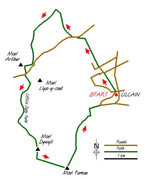
Part of this walk follows the Offa's Dyke Path on the Clwydian Range of hills. On a clear day views are over the Vale of Clwyd to Snowdonia (Eryri), the Isle of Man and the North West of England. The start is from Cilcain village near Loggerheads. The car park marked on the map opposite the church has a notice warning "that the gate may be locked at any time" so take the lane at the side of the church down to the bottom over the stream then left to park under the tree by the large grey building (Grid ref. SJ172647).
From this point walk up the lane back to the church, cross over the road and take the path to the right of the car park in a north-westerly direction. This path follows the fences across the fields to a lane. Keep straight on down the lane and over the stile in front of you. The path again crosses fields and the line is generally straight ahead. On reaching the woods on the left, go down hill aiming for the right hand corner of the field. Be warned it can be very wet underfoot here! Cross over the stream and turn left, going between the gate posts then up towards the right hand corner of the field and over the stile in the hedge to a road (Grid ref. SJ162670).
Take the stile opposite going straight ahead over the stream and up into the woods. Follow the path in the woods straight ahead of you, then the wide path on the left that leads to a five bar gate (grid ref. SJ156677). The wooden structure in the fence on your left is one of the many horse jumps you will see in this area. Turn left on a wide path, skirting woods on your left. The view begins to open out as you climb steadily towards Moel Arthur. Before the path drops down to a road ahead, take a path to the right climbing up to the old fort on Moel Arthur 456m (Grid ref. SJ145660).
Make your way down the path from the summit to the road and car park. Cross over the road and then go straight up the very steep path - not the gentle path skirting the hill to the left. Just think of the exercise! Reaching the top just follow the Offa's Dyke Path along the ridge to Jubilee Tower on Moel Famau (554m). The tower, built to commemorate the 50th year of reign of George III, was never completed and destroyed in a storm. It now provides shelter from the wind and exceptional views on a clear day embracing Snowdon, Cadair Idris, the North Wales coast, River Dee, the Lake District and the Isle of Man.
Take the steep path down from the tower to the northeast, which is to the left of your approach path. This path skirts woods on the right. You will come to a path direction finger post. Keep straight on down the very steep path. This levels off, passing a small reservoir on the right to reach a lane. At the road turn left then the next turning right which leads back to Cilcain and the start.
Messaging & Social Media
Message Walking Britain and follow the latest news.

Mountain Weather
Stay safe on the mountains with detailed weather forecasts - for iOS devices or for Android devices.