Walk 2593 - printer friendly version
Liathach, Glen Torridon Walk
Author - Paul Gasson
Length - 8.5 miles / 13.8 km
Ascent - 4450 feet / 1348 metres
Grade - very hard
Start - OS grid reference NG936566
Lat 57.552242 + Long -5.4513366
Postcode IV22 2ET (approx. location only)
This is a stunning and challenging walk over one of Scotland's real giants!
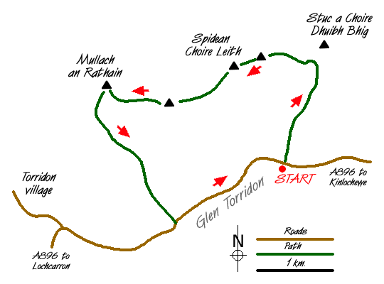
Take the narrow road ( A896) up the glen from the village of Torridon, to a lay by at NG936566, close to the Allt a Doire Gharb. The seemingly impossible bulk of Liathac towers above you and the hard work starts almost from the road. No worries about a long walk in HERE!
A narrow path climbs steeply up the right hand side of the stream ( true left bank!) towards Coire Liath Mhor high above. Follow the path almost to the mouth of the great cleft in the cliffs above, from where the path traverses right to gain the ridge just short of Stuc a Choire Dhuib Bhig. This will probably take about two hours, or more!
Follow the ridge more of less West, over a number of minor tops, towards the main peak of Spidean a Choire Leith. The views from here are stunning in every direction, given good weather (always at a premium in Torridon!) and the summit is probably a good spot to take a lunch break before continuing.
The path onwards is vague, but leaves the summit in a southerly direction, before making its way steeply down over rocks to the Am fasarinen Pinnacles. Competent scramblers will want to tackle the Pinnacles directly, which present few real difficulties other than considerable exposure, making the use of a rope prudent in parts. The alternative is a horizontal path to the south side of the pinnacles. This weaves in and out around the Pinnacles, nowhere difficult at all, but very narrow and with a vertical drop to one's left to the glen road nearly 3000ft. below. A final turn brings the end of the narrow path, and a broad, easy angled shoulder leading up to the final peak, Mullach an Rathain to complete the traverse.
The descent path leaves the summit just west of south at first, then turns almost due south to drop into Toll Ban over steep but easy scree, then steep, ankle turning grass slopes until you reach the stream of Allt an Toll Bhain and a clear path back to the road about a mile and a half from your car! At least the waters of the River Torridon offer refreshments to one's feet before the trudge back up the glen to complete a walk that should live in your memories for many years.
NOTE! In the foggy weather which often prevails in Torridon, route finding and navigation will be at a premium and I would suggest this route ONLY be attempted under ideal weather conditions.
Messaging & Social Media
Message Walking Britain and follow the latest news.

Mountain Weather
Stay safe on the mountains with detailed weather forecasts - for iOS devices or for Android devices.