Walk 2700 - printer friendly version
Yieldingtree from Churchill Walk
Author - Peter Lane
Length - 5.5 miles / 8.9 km
Ascent - 420 feet / 127 metres
Grade - easy
Start - OS grid reference SO884796
Lat 52.414273 + Long -2.1719717
Postcode DY10 3LT (approx. location only)
This figure of eight walk explores a part of rural Worcestershire where horse ownership features strongly. You are quite likely to see an impressive "shire" horse on this route. The old forge at Churchill is near the start/finish point, as is the mill pool that feeds it. This walk is not suitable for anyone with a fear of farmyard animals, particularly horses or cows!
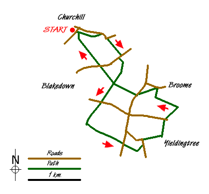
Start in the hamlet of Churchill at grid reference SO884796, parking on the road at the start of the footpath signed to Stakenbridge. Without crossing the bridge, continue over a metal stile along the banks of the pool. Continue in the same direction through a variety of stiles until reaching Stakenbridge Lane. Turn right here, go under the railway bridge and head for the bridlepath straight ahead: the Monarch's Way. Follow this to Harborough Farm and the A456.
Cross the main road and go right for a few metres. Continue down the bridlepath and follow the waymarks around Broome Mill. Follow the Monarch's Way along the boundary of a wood and cross the B4188 at the top of Blakedown. Continue opposite (signposted New Wood Lane) and walk past paddocks down to a muddy spot. As the path rises, a stubby waymark post indicates a bridlepath to the left while the Monarch's Way continues uphill. Take the left hand bridlepath past more paddocks.
As the bridlepath turns gently uphill to the right, a waymark next to a metal gate indicates the continuation of the path which eventually emerges onto the A450. Cross, go downhill for a few metres and take the footpath running through a field with the hedge-line to the left. As the hedge disappears, go half left on a bearing of approximately 78 degrees and follow this across an open field to a stile next to a metal gate. Turn left down the lane and then turn right along Water Lane (not signposted) at Yieldingtree.
At Top Farm, take the footpath through private property for a while and take careful note of the waymarks as they direct you to the next road: Hackman's Gate Lane (B4188). Cross and go over the stile directly opposite. Turn half right at the stile on an approximate bearing of 45 degrees and head for a stile. Over the stile, turn left and follow the hedge to the left until reaching another stile. Cross this and head in a straight line for another stile in the distance and from there to Hundred Acre Farm. Watch out for some more shire horses! Reaching the Farm's main access, there are rights of way across the field ahead, but I've never found them! Rather than spoil the crop, turn right down the main access, left onto Broome Lane and left again onto the main A450.
About 300 metres up the hill, take a footpath on the right signposted to Harborough Hill. Follow this path past a derelict farm building and descend through a small wood to come to a crossing point with the Monarch's Way and the outward route. The continuation is directly ahead across the field. Normally this is well trodden, but may disappear if freshly ploughed. There is a waymark directly opposite on the boundary of the beige house. Head straight for this and follow the waymarks past the house, two small pools and then slightly uphill emerging into an open field and a marker post.
The continuation is across the field: keep the white house on Harborough hill to the right and taking a bearing of 327 degrees head for a solitary tree which hides a stile to its right that becomes visible after climbing the incline for a short way. Cross the main A456 and a short distance down the hill on the right is the continuation path. Follow this crossing a bridlepath and then the railway. Emerge at the mill pool at the start of the walk.
On the left you will see Churchill Forge, now maintained by English Heritage. Built in 1800 on the site of a 13th century water mill, this forge used water to turn its water wheel that powered hammers used for making spades and shovels.
Messaging & Social Media
Message Walking Britain and follow the latest news.

Mountain Weather
Stay safe on the mountains with detailed weather forecasts - for iOS devices or for Android devices.