Walk 2823 - printer friendly version
Greasley & Moorgreen Reservoir Walk
Author - Lou Johnson
Length - 5.9 miles / 9.6 km
Ascent - 400 feet / 121 metres
Grade - easy
Start - OS grid reference SK480480
Lat 53.0271430 + Long -1.2857774
Postcode NG16 2FF (approx. location only)
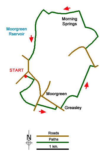
The Nottinghamshire town of Eastwood and the surrounding area has many associations with the author D H Lawrence. This walk explores the countryside to the east of the town and uses paths and tracks that are generally well trodden. The start is the small car park at Colliers Wood Nature Reserve (grid ref. SK480480).
After parking turn right (east) out of the parking area and follow the clear path. After 300 metres turn right and walk south-west again on a clear well-surfaced path. After 500 metres (grid ref. SK479475) turn left onto a path. This path follows the field boundary on your immediate left, does a left-right dogleg and continues as an enclosed path to the B6010. Turn left and, in less than 100 metres, turn right onto a signed path to Greasley. Reaching the Parish Church, bear left to the B600 (grid ref. SK489472).
Turn right along the B600 and just after the driveway to a large house on the left, take the footpath on the left (grid ref. SK491471). The path crosses fields and after just over a mile reaches a road just north of Brookbreasting Farm (grid ref. SK500483). Turn left (north) along this road to reach a small parking area on the right (grid ref. SK498488). Note this can be used as an alternative starting point for this walk. Turn right here onto a clear path/track running along the right hand side of a field to reach the M1. Stay on the clear path/track as it parallels the Motorway before entering woodland. Continue through the woodland following the waymarked path to reach a clear track along the northern edge of the woodland (grid ref. SK496499).
Turn left on the clear tarmac track and follow the northern perimeter of the woodland. Just before Felley Mill (grid ref. SK486499) go left and follow the track heading south through High Park Wood, with Moorgreen Reservoir on your right. This track leads out onto the B600 at Beauvale Lodge (grid ref. SK481485). Bear left along the B600, taking care, and at the first junction reached after 300 metres, turn right and the car park used at the start is a short way down this road on your left.
Messaging & Social Media
Message Walking Britain and follow the latest news.

Mountain Weather
Stay safe on the mountains with detailed weather forecasts - for iOS devices or for Android devices.