Walk 2824 - printer friendly version
Arkaig Hills Circular Walk
Author - Peter Smyly
Length - 8.8 miles / 14.3 km
Ascent - 1550 feet / 470 metres
Grade - moderate
Start - OS grid reference NN177888
Lat 56.9544120 + Long -4.9993556
Postcode PH34 4EJ (approx. location only)
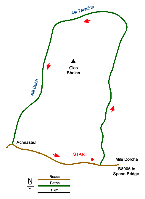
For people who like to walk 'off the beaten track' and to escape from crowds of people, it does not get much more remote than this. The Arkaig Hills are located in one of the parts of the Scottish north-west highlands where other walkers are less likely to be seen than the occasional deer in the distance.
Follow the B8004 road from Spean Bridge leading to the B8005 and, in particular, the stretch of road called the Mile Dorche (the dark mile) to the north of Loch Lochy, to reach the start point of the walk. This is a suitable choice of walk for a day when the tops are in cloud and a lower level walk is preferred. Despite the seemingly moderate length of this walk, some of the terrain that the route passes over can be energy-sapping, resulting in the walk feeling longer than it actually is. Not only do you need to contend with walking over felled trees and similar vegetation in places, other parts of the walk involve a mixture of peat, bog, coarse grass, stones, cotton grass, and pools of water where paths either do not exist or do but then peter out. The walk follows a circular route in an anti-clockwise direction around a hill called Glas Bheinn. Although it does not look particularly high, Glas Bheinn is no mere hill at a height of 732 m (2401 ft). While climbing it is one possible option, there was no sign of a path and the terrain is no less favourable than some of the trickier sections that are more on the level. This top appears therefore to be one for the dedicated 'hill-bagger'. This walk includes no summits but the more pretty aspects of the walk come in a series of waterfalls in the upper part of the valley while some of the distant hills form graceful curves along a ridge. The landscape as a whole gives a feeling of being particularly remote and seldom-visited by humans. In the latter part of the walk, Loch Arkaig is clearly seen with a couple of tree-clad islands.
Previously, the recognised starting point for this walk was from the car park at grid reference NN177888 where a plunging waterfall called the Eas Chia-aig enters the river near to the end of Loch Arkaig. However, the path up from here has been affected by fallen trees resulting from deforestation activities and so as long as the position remains, it is necessary to walk back along the Mile Dorcha road a few hundred yards to the east to locate a forestry track that winds its way up. This is a very clear route for the first few miles, a wide track that rises high above the river below on the left, which runs along the Gleann Cia-aig valley. However, this track reaches an abrupt halt and it is necessary to follow a path instead to continue towards the head of the valley.
As the path loses height on approaching a forest, there are more felled trees to clamber over. Beyond the forest, a wooden footbridge provides access to the other side of the river and the next few hundred yards feature some fine cascades and waterfalls as a path more or less follows the course of the river to the left, the Allt Tarsuinn which runs along the Gleann Tarsuinn but it becomes indistinct before fizzling out. This is, in my opinion, the prettiest section of the whole walk. However, the path appears and disappears and the best option may be to stay on the right side of the meandering course of the stream. The view back reveals a line of shapely curved hills which appear to be very remote. Once this retrospective view has disappeared over the brow of the hill, the path heads down alongside the west side of Glas Bheinn with distant views of Loch Arkaig ahead below, a reminder of how much height still needs to be lost. With little to distract one's attention, the key now is to follow the route down to where it reaches a tarmac road. Turn left here.
Having completed three sides of the route, the final section is along a secondary tarmac road and while road walking may not normally be a preferred option, in this instance it is quite welcome as a change from all the peat, bog, tussocky grass etc earlier in the walk.
Loch Arkaig, with its pair of wooded islands, offers a view on the right, initially offering just tantalising glimpses between trees, but much clearer views open out lower down. The road leads back to the start of the walk.
Messaging & Social Media
Message Walking Britain and follow the latest news.

Mountain Weather
Stay safe on the mountains with detailed weather forecasts - for iOS devices or for Android devices.