Walk 2832 - printer friendly version
The Wye Valley Walk
Author - Lou Johnson
Length - 5.8 miles / 9.4 km
Ascent - 900 feet / 273 metres
Grade - easy/mod
Start - OS grid reference SO539011
Lat 51.7067330 + Long -2.6685495
Postcode NP16 7NG (approx. location only)
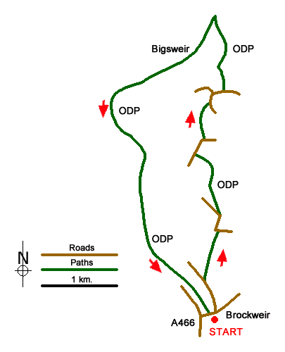
The areas to either side of the River Wye provides some excellent walks through lovely countryside. This route starts at Brockweir a mile or so miles along the A466 north from Tintern Abbey. The walk uses sections of the Offa's Dyke Path, which is generally well waymarked and easy to follow. Limited on street parking is available in Brockweir (grid ref. SO539011). In addition, the Brockweir Inn will allow parking providing walkers patronise the pub.
After parking take Underhill, a narrow lane unsuitable for motor vehicles just across from the Brockweir Inn. After 400 metres at Orchard Cottage (grid ref, SO 538015), turn right up the restricted byway and continue in a northerly direction for about 650 metres.to reach a junction with a lane at The Paddock (grid ref. SO539021). At this point the lane is also the route of the Offa's Dyke Path.
Turn left along the lane and in about 150 metres bear right off the lane and follow the Acorn waymarks of the Offa's Dyke Path. Across fields. Eventually the ODP re-joins the lane (grid ref. SO537031). Turn right and after 200 metres (where the lane bends right) continue ahead on the ODP (grid ref. SO538032). The ODP path leads onto another lane at grid ref. SO539037. Turn left and at the next junction bear right. A short way along on the left, turn left and continue along the ODP. The path soon enters woodland and descends into the Wye Valley.
You emerge from the woodland into open fields still descending. Away to your left is Bigsweir House. Reaching a flatter area and the driveway for Bigsweir House (grid ref. SO539048), turn left. The onward route bears to the right of Bigsweir House to re-join the valley route of the ODP at grid ref. SO537044). Continue south alongside the River Wye for about 5 km to return to the start.
Messaging & Social Media
Message Walking Britain and follow the latest news.

Mountain Weather
Stay safe on the mountains with detailed weather forecasts - for iOS devices or for Android devices.