Walk 2922 - printer friendly version
Old Hunstanton to Thornham by the Coast Path Walk
Author - Lou Johnson
Length - 4.5 miles / 7.3 km
Ascent - 50 feet / 15 metres
Grade - easy
Start - OS grid reference TF681425
Lat 52.9535380 + Long 0.5008397
Postcode PE36 6JL (approx. location only)
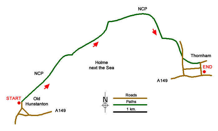
The North Norfolk Coast offers a variety of scenic and wildlife interest and this walk is no exception. The start is the large pay and display car park in Old Hunstanton (grid ref. TF681425) which lies a short distance off the main A149 Coast Road just east of Hunstanton. The route is easy to follow and is well-waymarked with the path along the coast being part of the Peddars Way and Norfolk Coast Path National Trail.
Before starting it is worth exploring the beach area at Old Hunstanton with its cliffs comprising of layers of chalk and sandstone. To start the walk, follow the clear marked Norfolk Coast Path in an easterly direction with the sea to your left. Initially the path passes through sand suns dotted with beach huts so typical of this coast. On you right is a links golf course. Reaching Flaxley, the path briefly turns inland to reach a junction of paths (grid ref. TF696439. Turn left here and continue along the coast passing an area of saltmarsh to your left.
The onward route passes a small plantation on your right (grid ref. TF715450) and then enters the Holme Dunes National Nature Reserve. Turning south, the path passes more saltmarsh on your right. The path bears left and then right again to join Staithe Lane. Walk south along the lane to reach a waymarked path on your left (grid ref. TF728438). Follow this path (signed Norfolk Coast Path) and continue to reach a road on the edge of Thornham village (grid ref TF733437). Bear right down this road to the main road and the end of the walk. There is a "Coast Hopper" bus stop close by for an easy return to Old Hunstanton and the start of the walk.
Note - There is an excellent bus service operating along the A149 coast road between Sheringham and Kings Lynn. Operated by Norfolk County Council, this "Coast Hopper" service is useful for many walks as the bus route shadows the Norfolk Coast Path. This enables one way walks to be undertaken with relative ease but also means that other walks can be altered to suit your needs. The drivers are usually very helpful and will advise where you should alight.
Messaging & Social Media
Message Walking Britain and follow the latest news.

Mountain Weather
Stay safe on the mountains with detailed weather forecasts - for iOS devices or for Android devices.