Walk 3032 - printer friendly version
Gragareth & Great Coum from Yordas Cave Walk
Author - Lou Johnson
Length - 9.0 miles / 14.6 km
Ascent - 1685 feet / 511 metres
Grade - moderate
Start - OS grid reference SD706790
Lat 54.205894 + Long -2.4522293
Postcode LA6 3PH (approx. location only)
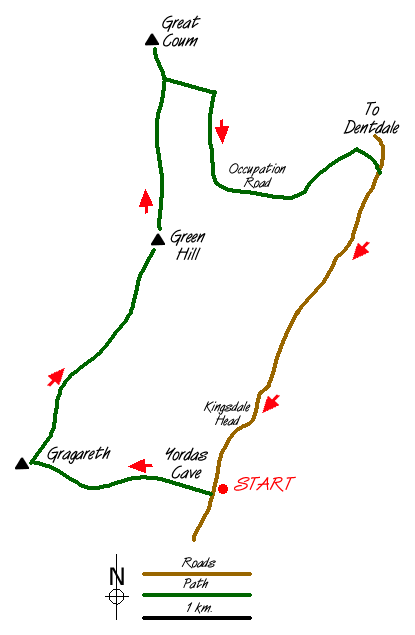
Although this Yorkshire Dales walk stays almost completely within or on the boundaries of the National Park, it feels more like the Pennines than the Dales. The start is close to Yordas Cave (grid ref. SD706790) on the gated road running the length of Kingsdale from Ingleton into Deepdale and on to Dent. The drive along Kingsdale is a good introduction to this area with the stepped outline of Ingleborough dominating the lower reaches, replaced by the more mundane shape of Whernside as you travel up the dale. In addition there are good views of the extensive limestone pavements in the area. Note that despite stiles, sections of this walk are not on rights of way and landowners' permission should be obtained.
After parking your car at the side of the lane, enter the gate that leads into the field containing the entrance to Yordas Cave. Apparently a visit to the cave is worthwhile although a large torch is needed to fully appreciate the size of the underground cavern. Follow the path on the northern side of a small dry gorge until you are clear of the trees. Here Yordas Gill disappears underground and you need to cross to the southern side of the gill.
There is a faint path (no right of way) heading north-west towards the sheepfold (grid ref. 696793). The path loosely follows the wall. From the sheepfold follow the wall up the steep gritstone escarpment and onto the ridge. Clamber over the ladder stile and head south west to the summit of Gragareth. From here there are wide ranging views across Lancashire to the sea, the Forest of Bowland, Ingleborough and Whernside. Return to the ladder stile. Head north along the western side of the wall, which forms the Lancashire/North Yorkshire county boundary. The clear path is easy going, although after rain expect it to be wet in places. It is an excellent ridge walk with good views on both sides. Before reaching the summit of Green Hill, you reach the point where Cumbria takes over as the county on the eastern side of the wall.
The final climb up the summit of Great Coum is easy and you are rewarded with a fine all-round panorama. In good visibility you can see the Lakeland Fells, the Howgills, a large portion of the fells forming the northern sector of the Yorkshire Dales plus Whernside the highest of the Yorkshire Peaks. To the south you can see along the ridge back to Gragareth and beyond. The easiest way off Great Coum is to follow the wall east. This descends to the Occupation Road, a green lane contouring around the hillside. On reaching the "Ocky" follow it south and then east to join the gated road climbing up Deepdale from Dent. This road leads easily back to your car. Although I prefer not to walk on tarmac this is a pleasant walk. Traffic is light and the surrounding scenery is interesting.
To extend the walk you could climb Whernside. A path leaves the gated lane (grid ref. 722818) and climbs straight to the summit. This adds around 1000 feet (300 metres) of ascent and a minimum of 2 miles (3 km) to the walk. For those with plenty of energy the best return from Whernside is down the south ridge eventually dropping down into Kingsdale using the limited footpaths and rights of way.
Messaging & Social Media
Message Walking Britain and follow the latest news.

Mountain Weather
Stay safe on the mountains with detailed weather forecasts - for iOS devices or for Android devices.